Good swell on the build with large west pulses next week
South Australian Forecast by Craig Brokensha (issued Friday May 24th)
Best Days: Every day this period South Coast, Mid Coast Tuesday
Features of the Forecast (tl;dr)
- Moderate sized mid-period S/SW swell building today with winds tending fresher E/NE into the PM
- Easing swell tomorrow with N/NE-NE tending E/NE-E winds into the PM
- Smaller Sun AM with local offshore tending variable winds
- Late increase in inconsistent SW groundswell Sun, easing Mon with local offshore tending variable winds
- Moderate + sized pulse of W'ly swell later Monday, peaking Tue AM
- Larger W'ly groundswell later Tue, peaking Wed AM
- Moderate N/NE tending lighter N/NW winds Tue
- Strong N/NE tending N winds Wed
- Reinforcing W/SW swell Thu with strong W/NW winds
Recap
The South Coast offered small, clean fun waves on the magnets yesterday, better today with some new, building mid-period S/SW swell energy under a light offshore wind.
We should see the South Coast reaching 4ft across Middleton and 1ft on the Mid Coast with variable winds in the gulf, fresher E/NE down South.

New swell starting to build at dawn
This weekend and next week (May 25 - 31)
This afternoon’s good pulse of mid-period S/SW swell should start to ease through tomorrow, down from 3-4ft across Middleton, tiny on the Mid Coast and with great N/NE-NE winds, tending E/NE-E into the afternoon.
Sunday morning looks smaller but with favourable, local offshore winds (N/NW South Coast), tending variable into the afternoon.
Now, later in the day Sunday and Monday morning, a new, inconsistent SW groundswell is due, generated by a strong but distant polar low that traversed under the Indian Ocean through this week.
Slow but good 3ft sets should be seen across Middleton on dark Sunday and early Monday, easing through the day with similar light local offshore winds to Sunday, and weak if not variable sea breezes
We then look at the strong W’ly swells due from later Monday/Tuesday through the end of next week across the state, generated by a flurry of strong mid-latitude frontal systems pushing through the southern Indian Ocean, towards and then under Western Australia.
This progression will be ideally aimed through the Mid Coast’s swell window, generating a bit of size, but winds won’t be ideal. They’ll favour the South Coast which will be less consistent owing to the shadowing effects of Kangaroo Island.
Coming back to later Monday/Tuesday’s swell, and this will be generated by the weakest of the incoming systems, with an initial fetch of gales due to weaken when pushing close to Western Australia tomorrow.
It’ll be inconsistent but should kick to 1-2ft later Monday and peak Tuesday to 2ft to occasionally 3ft on the Mid Coast with Middleton coming in at a slow 2-3ft.
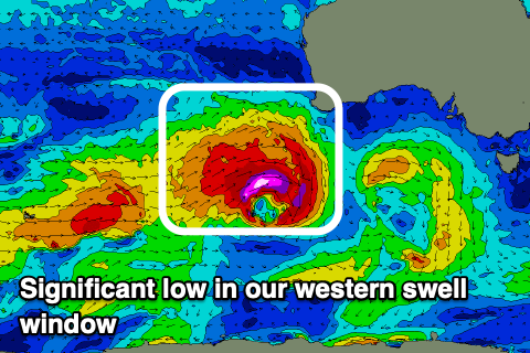
A much stronger low forming in the eastward progression of fronts this weekend should generate a great fetch of severe-gale to storm-force winds, producing a larger, more powerful W’ly groundswell that’s due to fill in later Tuesday afternoon and peak overnight, easing through Wednesday.

The Mid Coast looks to pulse to 3ft late with the large incoming tide, swallowed late, with Wednesday easing from a similar 3ft+, while Middleton looks to come in around 4-5ft+, though inconsistent.
Winds on Tuesday will be great for the South Coast and doable for the Mid with a N/NE tending N/NW breeze, moderate in strength across the Mid but lighter after lunch.
Wednesday looks average in the gulf with strengthening N/NE tending N winds adding lots of chops and ridges as well as some N’ly windswell. The South Coast will be great though with quality waves all day, easing Thursday as winds shift strong W/NW.
This shift in wind will be associated with a weak front moving through the Bight, and the earlier stages of this front, south-west of WA should generate a reinforcing W/SW swell to 2-3ft in the gulf Thursday.
Unfortunately the strong onshore winds will create poor conditions for the Mid Coast, holding from the NW on Friday. We’ll confirm this and the timing and sizes of the coming westerly swell Monday. Have a great weekend!


Comments
We made it! Bring on the west swells