Easing south swell ahead of some new west swell later week
South Australian Forecast by Craig Brokensha (issued Monday March 4th)
Best Days: South Coast this morning for the keen and experienced but more so tomorrow, Mid Coast later Thursday but more so Friday, South Coast Friday morning, South Coast Saturday
Features of the Forecast (tl;dr)
- Steadily easing S'ly swell tomorrow with N/NE tending SE winds down South
- Smaller Wed with variable winds, tending S'th and freshening into the PM
- E/SE-SE winds Thu AM with a low point in swell, tending S/SE
- Late increase in moderate sized W/SW swell Thu, peaking Fri with E/SE winds on the Mid, NE down South ahead of sea breezes
- Easing swell Sat with N/NE tending fresher N/NW winds
- Small Sun with S winds
Recap
Super fun waves and conditions across the Mid Coast all weekend with pulses of W/SW-SW swell energy coming in at 2ft both Saturday and Sunday, though most consistent on the former.
The South Coast was bumpy and generally average with plenty of size but those winds from the south-eastern quadrant.
This morning the W/SW-SW energy is on the wane in the gulf, but a large new S’ly groundswell is breaking across the South Coast with slightly better conditions under an E/NE breeze. Options are limited under this combo though.

Fun surf Saturday
This week and weekend (Mar 5 - 10)
This morning’s large pulse of S’ly groundswell will ease this afternoon and drop steadily through tomorrow thanks to the low that generated it moving rapidly through our swell window on the weekend.
Conditions should be much cleaner tomorrow morning though as winds shift N/NE across the South Coast along with easing 3ft to possibly 4ft sets (tiny in the gulf). Sea breezes look relatively weak so there’s time for a couple of surfs tomorrow morning.
Moving into Wednesday and the swell looks to bottom out, back to 1-2ft and early variable winds are due to slowly increase from the S’th, freshen into the afternoon as a trough moves through. Therefore with this outlook make the most of tomorrow.
Thursday will be a lay day down South with generally SE winds and no new swell until the afternoon but more so Friday. The Mid Coast should see some surfable waves starting to show, discussed in more detail below.

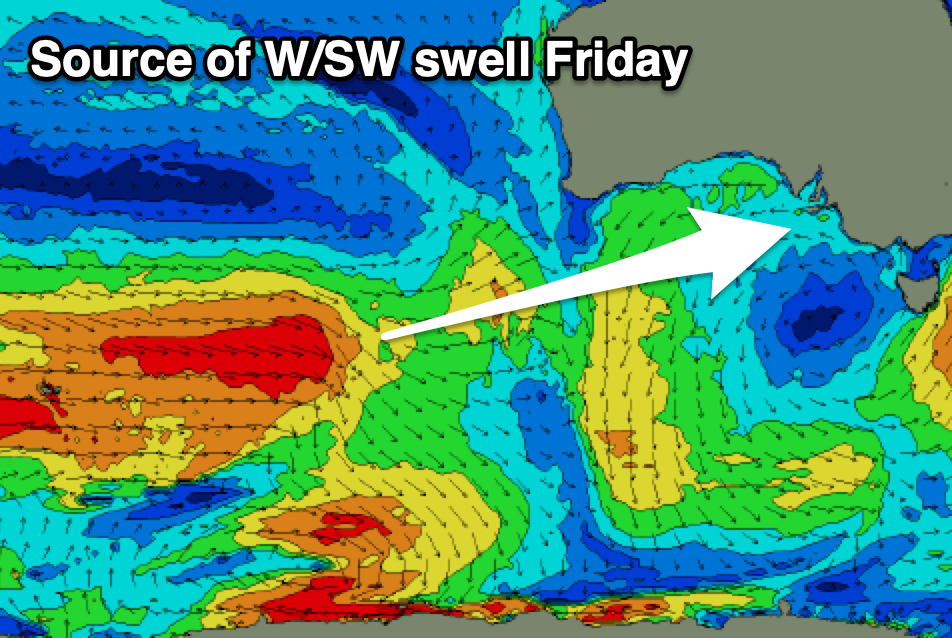
The source of this W/SW swell is a healthy but distant frontal progression kicking up to the south-west of Western Australia, generating back to back fetches of strong to gale-force W’ly winds. The progression will weaken while moving east, slowly under the country through the week and this should extend the swell longevity into the weekend while tending more SW in direction.
Later Thursday we should see building sets to 1-1.5ft on the Mid Coast, while a peak is due Friday with inconsistent but good 1-2ft sets due in the gulf. Middleton should come in at 3-4ft on Friday, easing from 3ft Saturday (1-1.5ft Mid Coast) and conditions look favourable for both coasts Friday, variable offshore ahead of sea breezes and then N/NE tending N/NW down South Saturday as the next trough approaches from the west (onshore Sunday).
Longer term, there’s a bit more action firing up for next week but we’ll have a closer look at this on Wednesday.

