Good westerly swells inbound with workable winds
South Australian Surf Forecast by Craig Brokensha (issued Monday April 10th)
Best Days: Both coasts today, South Coast tomorrow, Thursday Mid Coast, Friday both regions, Saturday South Coast
Features of the Forecast (tl;dr)
- Inconsistent SW groundswell Tue/Wed/Thu
- Strengthening N/NE tending NE winds tomorrow
- Strong W/NW tending W/SW winds Wed with a building windswell on the Mid Coast
- Mix of moderate sized mid-period W/SW swell and building W/SW groundswell Thu, holding Fri
- Gusty S winds Thu (S/SE in the AM on the Mid)
- Local offshore winds Fri AM, freshening from the N/NE-NE
- Stronger N/NE tending NW winds Sat with an easing mix of swells
- Building W/SW swell from Sun, peaking Mon
Recap
A terrible weekend of surf with a junky windswell on the Mid Coast easing back from 1-2ft Saturday, tiny Sunday with building levels of onshore surf down South, peaking yesterday to 3-5ft.
This morning we've got much cleaner conditions, better than I expected with plenty of S'ly swell in the water still to 3-4ft. The Mid Coast is clean but slow and picking up a sneaky 1-1.5ft of swell.
This week and weekend (Apr 11 - 16)
Looking at the week ahead and we've got good conditions due again down South tomorrow before a mid-latitude low pushes east and across us, bringing a strong W/NW tending W/SW winds through the morning Wednesday.

Coming back to tomorrow, and we'll see the S'ly swell currently in the water easing, as some new, inconsistent SW groundswell arrives, generated by a distant polar front last week. It'll be slow but sets to 3ft are due across the Middleton stretch while being tiny on the Mid Coast. Winds will strengthen from the N/NE tending NE through the morning so target those easterly friendly breaks.
Wednesday will be a little slower and smaller with a background swell maintaining 2-3ft sets across Middleton, while the Mid is due to kick to 2ft+ with a mix of locally generated windswell and mid-period swell.
Thursday will be a lay day down South with gusty S'ly winds in the wake of the mid-latitude low on Wednesday, while the Mid Coast should be fun and cleanish during the morning with inconsistent sets to 2ft on the favourable parts of the tide.
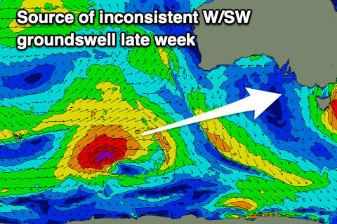
Into the afternoon some new, inconsistent W/SW groundswell is due, followed by a secondary pulse through Friday afternoon, generated by back to back lows projecting up from the Heard Island region, towards Western Australia.
An initial tight low is generating a fetch of gale to severe-gale W/SW winds, while a secondary system will push in on the back of the first though a touch smaller in scope.

Realistically it looks like both swells now will come in around the same size, with the first pulse for Thursday afternoon pushing to 2ft to occasionally 3ft with the incoming tide, maintaining this size on the favourable parts of the tide Friday.
The South Coast should see inconsistent 3-4ft sets across Middleton later Thursday, holding Friday and winds are due to be locally offshore across both coasts with an E/NE breeze on the Mid and N/NE winds down South. Winds look to be favourable all day down South, going a little northerly on the Mid, with strengthening N/NE tending W/NW winds ahead of another, strong mid-latitude low forming in the Bight on Saturday as the swells ease.
Now the models currently diverge regarding the strength of this mid-latitude low, with GFS going all out as usual, which would result in a large W/SW groundswell for later Sunday/Monday, but EC is weaker and not as interesting. Check back here on Wednesday for a clearer idea on what's in store.

