Strong swell inbound but with dicey winds

South Australian Surf Forecast by Craig Brokensha (issued Wednesday March 29th)
Best Days: Thusday morning for the keen South Coast, Friday afternoon keen surfers South Coast, Mid Coast for the keen Saturday, South Coast Sunday and Monday mornings
Features of the Forecast (tl;dr)
- Fading surf Thu with W/NW tending SW winds late AM
- Low point in swell Fri AM with a W/NW tending SW breeze late AM, freshening from the S/SW
- Moderate sized SW groundswell building Fri PM with the S/SW winds, peaking Sat with mod-fresh SE tending S/SE winds
- Easing surf Sun with moderate E/NE tending S/SE winds
- Smaller Mon with NE tending SE winds
Recap
Great conditions and surf most of the day down South yesterday with plenty of swell continuing around the 3ft range from the south with weak afternoon sea breezes. Today is poor with an onshore change and smaller 2-3ft surf. The Mid Coast has been tiny to flat for the most part.
This week and weekend (Mar 30 – Apr 2)
The end of the week isn't too flash thanks to a further drop in swell, only kept in the 2ft range tomorrow morning thanks to background energy, down to 1ft to occasionally 2ft on Friday morning.
Winds will improve and swing to the W/NW tomorrow morning but you'll need to keep your expectations lowered down South, shifting SW late morning. Friday looks to play out similarly, and a strong new SW groundswell is due to pulse through the afternoon. This will be with those onshore winds, freshening from the S/SW later but regardless the strength of the swell should still provide some OK waves for a paddle post working week.
The source of this swell which will peak through Saturday morning is an impressive polar frontal progression that's formed to the south of the country. A broad and elongated fetch of gale to severe-gale W/SW winds are being generated, with a slight weakening due through today ahead of a trailing fetch of SW gales this evening, weakening while projecting up and into us Friday.
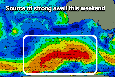
This will generate a good, prolonged swell that will have some legs, only easing slowly through Sunday. Following weak fronts will continue to slow the easing trend through Monday and Tuesday before bottoming out Wednesday.
Friday afternoon should build to 4ft on the sets, with a peak due Saturday morning to 4-5ft across Middleton (possible rare bigger cleanup). The Mid Coast should see 1ft+ sets later Friday with infrequent 1-1.5ft waves on Saturday.
Unfortunately local winds will be poor and moderate to fresh from the SE tending S/SE on Saturday, favouring the tiny Mid Coast.
The swell should still be solid and to 3-5ft on Sunday morning as winds slowly improve, shifting E/NE through the morning ahead of SE sea breezes. This will create cleaner faces but the swell is likely to still be lumpy and not ideal.
A weak trough pushing slowly east should tip winds more NE on Monday morning as the swell continues to drop back from 3ft or so across Middleton, with deteriorating conditions under freshening E winds likely Tuesday.
Longer term the outlook is too dynamic and the models divergent to be confident on so check back Friday and next week for a much clearer idea on what's due into the Easter Long Weekend.
Comments
Looking crap for Easter.