Fun tomorrow with swell for the weekend but with average winds
South Australian Surf Forecast by Craig Brokensha (issued Monday March 27th)
Best Days: Now South Coast, tomorrow South Coast, beginners Mid Coast Saturday
Features of the Forecast (tl;dr)
- Easing mid-period S/SW swell tomorrow, further Wed
- Light NW tending weak SE tomorrow, fresh S'ly Wed
- Fading surf Thu with W/NW tending SW winds
- Low point in swell Fri AM with a NW breeze
- Moderate sized SW groundswell building Fri PM with a S/SW change, peaking Sat with fresh S/SE-SE winds
- Easing surf Sun with fresh E/SE-SE tending S/SE winds
Recap
Lumpy surf with a building swell on Saturday, much better yesterday down South with light offshore winds and a peak in S/SW energy to 3-5ft. The Mid Coast failed to see any real size owing to the southerly direction of the incoming swell.
This morning the swell was still chunky but on the ease with 3ft+ sets across Middleton, tiny and wind affected on the Mid Coast.
This week and weekend (Mar 28 – Apr 2)
Today (ahead of sea breezes) and tomorrow will be worth making the most of before the swell fades and onshore winds kick in for the weekend.
The weekend's swell will continue to ease through tomorrow, with dropping mid-period energy down from 2-3ft across Middleton, while being tiny on the Mid Coast. Wednesday looks smaller again with 2ft leftovers, fading further from 1-2ft on Thursday and bottoming out Friday morning.
Locally winds will be good tomorrow and offshore NW, giving into weak SE sea breezes, and then tending fresh S'ly on Wednesday as an inland surface trough across Victoria pushes east.
The weak nature of the trough will see winds go back to the W/NW down South early Thursday morning but with the small, fading swell, NW on Friday morning but tiny.
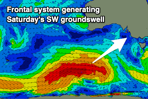
Into Friday afternoon a strong pulse of new SW groundswell should arrive, generated by a strong polar frontal progression forming to the south-southwest of Western Australia tomorrow.
A great fetch of gale to severe-gale W'ly winds should be produced through our south-western swell window, weakening through Wednesday evening in our southern swell window but still maintaining a fetch of W/SW winds.

This will prolong the swell event, with a late increase in size due Friday, building to 4ft on the sets by dark across Middleton, peaking Saturday morning to 4-5ft. The Mid Coast isn't due to see much size from this swell with sets to 1-1.5ft max on the favourable parts of the tide Saturday.
Unfortunately a high will move in Friday afternoon, bringing freshening S/SW winds as the swell starts to build, fresh out of the S/SE-SE Saturday as the swell peaks. Winds will remain fresh and tend more E/SE on Sunday as the swell starts to ease from the 4ft range down South, smaller into early next week but with persistent winds from the south-eastern quadrant thanks to persistent high pressure across the mid-latitudes.
We may see the pattern break down later next week, bringing more favourable winds but smaller surf, but we'll review this Wednesday.


Comments
Hey Craig, still too early for bells forecast?
Will have a FC tomorrow.
Cheers bro
Hey Craig, is the guy at knights cleaning the cam anymore? It’s been blurry for over a month now. Happy to do it for him if he allows access to his front garden hose hahaha
Thanks Jasper, but it's got a crack in it, and that's the blur. We've got a replacement to be installed hopefully soon.
Agh, I see it's very blurry as well. Will try and get it cleaned.