Plenty of swell and wind inbound
South Australian Surf Forecast by Craig Brokensha (issued Wednesday August 17th)
Best Days: Protected spots Friday afternoon South Coast, Saturday Mid Coast, Sunday both coasts, Tuesday Mid Coast, Wednesday both coasts
Features of the Forecast (tl;dr)
- Low point in swell down South tomorrow with a building NW tending W windswell on the Mid with strong NW tending W/SW winds mid-PM
- Moderate sized mid-period W/SW swell for Fri (peaking PM down South) with strengthening W/NW winds
- Mix swells Sat ahead of a new W/SW swell into the PM
- Fresh SW tending S/SE winds down South Sat, moderate S/SW-S tending SW on the Mid and then S/SE later
- Moderate sized W/SW swell for Sun, easing into the PM with N/NW winds down South and N/NE-NE tending N winds on the Mid
- Smaller surf Mon with strong N/NW tending W/NW winds
- New SW groundswell Tue with S winds, with mid-period energy on Wed with W/NW tending W/SW winds
Recap
A building W/SW swell through the day on the Mid Coast yesterday from a tiny 1-1.5ft in the morning to 1-2ft into the afternoon but with onshore winds. The South Coast was a mess early but onshore wind eased right back into the afternoon creating cleaner conditions for the keen.
Today the localised swell for both regions has eased back in size but the South Coast is nice and clean with 1-2ft leftovers, bumpy and tiny on the Mid.

Fun waves down South this AM
This week and weekend (Aug 18 - 21)
Tomorrow will be a lay day across the South Coast as the swell bottoms out under strong NW tending W/SW winds through the mid-afternoon as a strong mid-latitude front and attached low push east.
The Mid Coast will see a junky windswell to 1-2ft whipped up through the day but there'll be no quality.
Into Friday we should see a mix of mid-period W/SW and SW energy filling in across both regions, peaking into the afternoon.
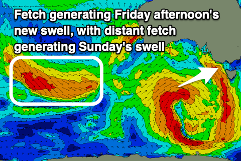
 These swells will be generated by a fetch of strong to gale-force W-W/SW winds wrapping around the low today as it strengthens south of the Bight and this should provide 2ft sets on the Mid Coast with the South Coast building to 3ft+ across Middleton into the afternoon (smaller in the morning).
Locally winds should be good in protected spots down South with fresh W/NW winds, strengthening through the day as the next front pushes in from the Bight.
Unfortunately Saturday will become poor down South as winds shift S/SW to S/SE in the wake of Friday's front, and the size eases back down from the 3ft range across Middleton. The Mid Coast should improve along with fun levels of W'ly swell hanging in the 2ft range, kicking more towards 2-3ft late in the day with the arrival of a new mid-period swell pulse.
This pulse will be generated by a fetch of strong W/NW tending W winds swinging in from the Indian Ocean, through the Bight and will peak Sunday across the South Coast.
Coming back to the Mid Coast and while it won't be perfect, easing S/SW tending SW winds should offer fun waves all day.
Looking at the winds on Sunday and N/NW breezes will create great conditions all day down South with 2-3ft sets across Middleton-Goolwa, N/NE-NE tending N on the Mid and with easing 2ft to occasionally 3ft sets.
We're looking at a low point in swell on Monday morning as winds strengthen from the N/NW, shifting W/NW into the afternoon as a broad, weakening low approaches from the Southern Ocean.
 This progression will actually develop south of South Africa today, moving east while slowly strengthening and consolidating. This initial polar low looks strongest south-west of Western Australia on on Friday afternoon and evening, with a fetch of broad strong to gale-force W/SW winds expected, with the low due to expand but weaken while projecting towards us through Sunday and Monday.
While not very well consolidated, this should produce a moderate sized SW groundswell for Tuesday coming in around 3-5ft across Middleton while the Mid Coast looks small and to 1-2ft. Conditions looks average for the South Coast with S'ly winds in the wake of Monday's change, though we'll have to confirm this Friday.
Some additional mid-period SW swell will be generated by this change, with Wednesday looking better with a morning W/NW breeze and waves continuing in the 3-5ft range across Middleton, 2ft on the Mid Coast. There's plenty more activity to follow but we'll have a closer look at this on Friday.


Comments
This winter has had the most number of small, clean days like in that photo that i can remember and Ive been surfing that coast for more than 20yrs. Very few big clean days this year
Agreed maddog.
Shit Autumn followed by crappier winter.
Does not bode well for spring + summer (which are generally rubbish anyway.).
Been a long 2 years or so.