Poor week of surf, improving from later Friday
South Australian Surf Forecast by Craig Brokensha (issued Monday August 15th)
Best Days: Later Friday South Coast, Saturday South Coast, Sunday South Coast
Features of the Forecast (tl;dr)
- Weak mix of easing swells tomorrow with gusty SW winds, easing into the PM
- Tiny Wed with mod-fresh N/NE tending stronger N/NW winds
- Tiny W swell building Thu PM with moderate N/NW winds
- Moderate sized mid-period W/SW swell for Fri (peaking PM down South) with strong SW winds, tending W/SW and easing, and then W/NW late
- Mix of W'ly swells Sat with fresh W/NW winds, tending SW later
- Easing W/SW swell Sun with NW winds
- Moderate sized SW groundswell building later Mon, peaking Tue with strong W/SW winds
Recap
A bit less well across the Mid Coast on Saturday but cleaner conditions with 1-2ft sets for the keen, tiny yesterday. The South Coast was the pick all weekend with a new pulse of S'ly swell and workable conditions in protected spots. Solid 3-5ft waves were seen on Saturday out of the S'th, a touch smaller and back to 3-4ft yesterday.
Today there was still plenty of S'ly swell in the mix down South with 2-3ft sets and clean conditions in protected spots. Winds will shift back W/SW-SW this afternoon (they just have) as the swell eases further. The Mid Coast is bumpy but flat.
This week and weekend (Aug 16 - 21)
The current synoptic setup sees the broad low responsible for our S'ly swell down South still sitting across Tasmania, but during this afternoon we'll see it starting to move east, bringing in gusty SW winds across the South Coast tomorrow along with a weak, small S/SW windswell. Winds will ease into the afternoon but there'll be no decent surf.
The Mid Coast should see more variable S'ly winds early but with a tiny 1ft of W/SW swell max.
A low point in swell is expected Wednesday but with cleaner conditions as the low clears further east and a mid-latitude front approaches from the west, bringing moderate to fresh N/NE winds, stronger N/NW into the afternoon.
This mid-latitude front will bring some new mid-period W/SW swell for Friday across both coasts, though just ahead of this on Thursday afternoon the Mid Coast may see some new W'ly swell kicking in though to 1ft or so. Winds should ease into Thursday but will remain out of the N/NW all day.
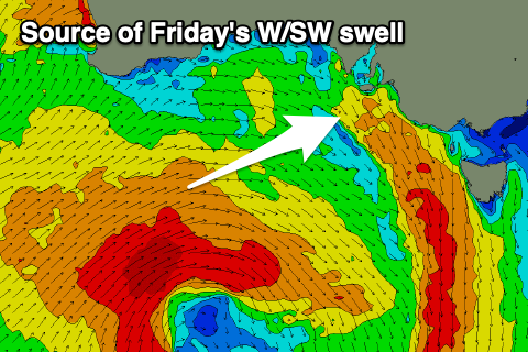
 Friday looks better, with a moderate sized mid-period W/SW swell due to fill in across both regions, generated by the front proper, producing a fetch of strong to gale-force W/SW winds.
Unfortunately the swell generating front will bring a strong SW change just before dawn, though easing and tending W/SW across the South Coast and even back to the W/NW later.
Swell wise, the Mid Coast should come in around 2ft but with those average winds, with building surf to 3ft+ across Middleton (possibly a touch undersized at dawn). With the improving conditions later, protected spots are worth a look.
The swell should start to ease into Saturday morning but a reinforcing pulse of mid-period W/SW swell is due into the late morning, generated by another mid-latitude front moving in later week.
This front will keep winds blowing out of the W/NW for most of Saturday ahead of a late SW change and the Mid Coast should kick to 2-3ft after lunch with Middleton holding around 3ft.
Cleaner conditions will be seen down South as the swell eases Sunday and winds shift NW, holding all day.
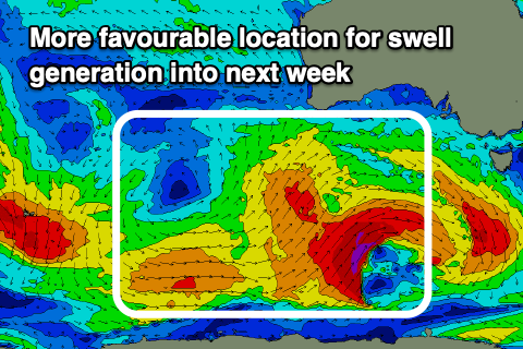
 Now, following this mid-latitude activity is finally some more promising Southern Ocean activity.
While not overly well consolidated we should still see a strong low generating a healthy fetch of W/NW tending W/SW gales. This should produce a moderate sized SW groundswell for later Monday, peaking Tuesday with a possible secondary follow up swell Wednesday from a secondary front projecting up and into us.
With these swells comes the wind though with strong west to south-west breezes due in general, cleaner on the backside of the progression. We'll have a closer look at this on Wednesday and Friday though.

