Fading surf into the weekend, new swell on the cards for next week
South Australian Surf Forecast by Craig Brokensha (issued Wednesday January 12th)
Best Days: This morning South Coast, Mid Coast beginners Monday, Mid Coast Tuesday
Features of the Forecast (tl;dr)
- Tiny, fading S/SE windswell tomorrow with W/NW tending fresh SW winds
- Tiny, inconsistent mid-period W/SW swell late Sun, peaking Mon with SE tending SW winds
- Moderate sized + SW groundswell building late Mon, peaking Tue with strengthening S/SE winds
Recap
Fun waves across the South Coast yesterday and this morning with favourable winds and peaky options to 2ft across Middleton, with the energy being weaker S/SE windswell today. The Mid has been tiny to flat but today there's 1ft+ of glassy swell sneaking in.


This morning's options
This week and next (Jan 13 - 21)
Looking at the outlook for the end of the week and we'll see the size bottom out across both regions as a weak low that's currently west of us pushes east, cutting off the infeed of S/SE windswell along with no new groundswell energy.
Winds will shift W/NW tomorrow morning ahead of afternoon sea breezes but there'll only be a weak, fading 1-1.5ft wave across Middleton. With the S/SE swell direction Waits and Parsons won't fair much better so it looks to be a lay day.
Friday should see NW winds again through the morning but with even less size. Unfortunately there's no new swell due into the weekend with unfavourable SW winds on Saturday, swinging E/SE on Sunday morning ahead of sea breezes.
Late Sunday but more so Monday, the Mid Coast is likely to see 1ft sets from a weak mid-latitude front pushing towards Western Australia today and tomorrow but of greater significance is a larger SW groundswell due Tuesday.
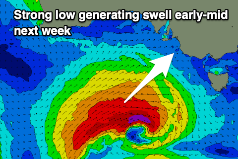
 Both Global Forecast Models now have a mid-latitude low deepening under Western Australia this weekend, generating a tight fetch of gale to severe-gale W/SW winds. The slow moving nature of the low should help generate a moderate sized + SW groundswell for late Monday but more so Tuesday.
Unfortunately a new ridge of high pressure moving in behind the low on Tuesday will bring strengthening S/SE winds, favouring the Mid Coast but it only looks to be 2ft.
As the swell eases Wednesday winds look to persist from the SE, but more on this Friday.

