Poor outlook thanks to La Niña
South Australian Surf Forecast by Craig Brokensha (issued Monday January 10th)
Best Days: Today South Coast, tomorrow morning South Coast
Features of the Forecast (tl;dr)
- Small, easing mid-period SW swell tomorrow with E/NE-NE winds ahead of weak sea breezes
- Building S/SE windswell Wed, persisting Thu, easing Fri. Fresh E tending strong S/SE winds Wed, strong SE tending S/SE Thu and light SW tending fresher S/SW winds Fri
- Weak, tiny W/SW swell for next Mon with S/SE winds
Recap
A low point in swell and gusty onshore wind Saturday, improving through yesterday with a small lift in new, mid-period SW swell and light E/NE-NE winds through the morning. A better pulse of swell for later in the day and today has come in nicely on the South Coast with 2-3ft sets across Middleton under favourable morning winds but the Mid has remained tiny unfortunately.
Conditions are now deteriorating and becoming bumpy down South with a freshening E'ly breeze.

Bumpy options late morning today
This week and weekend (Jan 11 - 16)
While the wind is starting to get into the surf a bit down South right now it'll be worth making the most of as the coming period isn't very favourable at all.
Tomorrow morning should still be fun but today's swell will be on the way out with easing, inconsistent 2ft sets across Middleton and Goolwa. The Mid will be tiny to flat. The wind should be out of the E/NE-NE again tomorrow morning creating clean conditions across selected spots ahead of light sea breezes as a trough starts to drift south across us.
This trough will support the formation of a low and we'll see it sitting just west of us through Wednesday, with a high moving under us resulting in fresh E;ly tending strong S/SE winds.
Swell wise there'll be no groundswell in the mix with a weak, building S/SE windswell due through the afternoon, persisting Thursday but with strong SE tending S/SE winds. We may see winds tend lighter SW on Friday morning as the low pushes east and the S/SE windswell fades, but with no quality swell in the water, it's a moot point.
 A new high pressure ridge will see winds freshen again from the S'th into Saturday, weaker into Sunday but with no new, noteworthy swell.
It's also worth noting that these persistent S/SE-SE winds will be upwelling cool, deeper water across the region, keeping ocean temperatures below normal, so pack a little extra rubber.
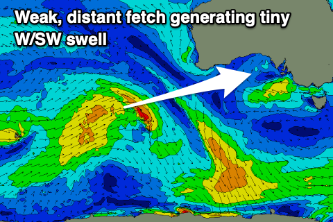
The Mid Coast will likely see a tiny, 1ft of swell Monday from a weak frontal system firing up in our medium-range swell window (shown right) but besides that there's nothing significant developing.
The succession of highs sliding in from the west across our mid-latitudes (a classic La Niña setup) means we'll continue to see no major swell generating storms into next week along with poor, persistent S/SE winds. Check back over the coming updates for an idea on when things will improve.


Comments
La Niña can royally get fkd, bring back the summer of 2016/17!! Any approximate idea how long this type of shitty pattern may last lads? I remember you had an article on it last year. Cheers legends.
The La Niña signal looks to have peaked and we'll see it weakening into the end of summer/early autumn. So we should be back to normal programming by autumn.
Lets fast forward Summer & skip & roll on to Autumn! Totally over Huey’s shitty SE winds
Lets fast forward Summer & skip & roll on to Autumn! Totally over Huey’s shitty SE winds