Average end to the year, better swell next week
South Australian Surf Forecast by Craig Brokensha (issued Monday December 27th)
Best Days: Keen surfers Thursday morning down South, Mid Coast Monday, South Coast Tuesday morning (next week)
Features of the Forecast (tl;dr)
- Easing mix of S/SW and S/SE swells tomorrow with gusty SE tending strong S/SE winds
- Further drop in swell Wed with light-mod S/SE winds, increasing
- Small mix of SW and S/SE swells Thu with variable tending S winds
- Fading mix of swells Fri with variable tending S winds
- Moderate sized, mid-period SW swell building later Sun, peaking Mon with fresh S/SE tending SW winds
- Easing swell Tue with NE tending SE winds
Recap
Christmas Day was best spent with family and friends as the swell reached a low point along with onshore winds down South, tiny and bumpy on the Mid Coast.
Sunday offered more size down South with a localised windswell and building S/SW groundswell but conditions remained poor.
There's still plenty of size on offer this morning with sets to 3-4ft and gusty SE winds down South, clean but flat on the Mid Coast owing to the blocking effects of Kangaroo Island.
This week and weekend (Dec 28 – Jan 2)
Looking at the coming week and unfortunately there's not much in the way of quality surf. Thursday is the one to target but the swell will be small.
Coming back to tomorrow and we'll see a moderate mix of S/SE windswell and easing S/SW swell along with fresh and gusty SE winds, strengthening from the S/SE into the afternoon.
On Wednesday a small trough is likely to bring early lighter S/SE winds but the surf wil still be all over the place and very morning sick with the lack off offshore wind. Expect sloppy, easing waves from 2-3ft. For me I'd rather a stronger onshore blowing adding strength to the swell rather than a listless, weak easing swell.
Thursday morning looks to offer better though still lumpy and peaky conditions with a variable breeze. There'll be small, fading levels of S/SE windswell along with a small, inconsistent mid-period S/SW swell.
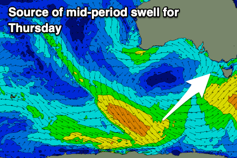
 The source of this swell was a weak trailing frontal system swinging down from the Indian Ocean, on the back of the strong polar frontal progression linked to yesterday's and today's S/SW groundswell.
Size wise it only looks to be 2ft max on the sets across Middleton and more so 1-2ft with 2ft+ waves at Waits and Parsons. The Mid Coast is due to remain flat with the southerly swell direction.
Friday morning will offer variable winds again but unfortunately the surf will be at a low point and tiny down South.
There's nothing of note into the weekend and conditions will be favourable early Saturday ahead of a trough and S/SW change during the morning, strengthening from the S/SE on Sunday as a new high moves in from the west.
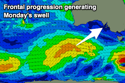
 We should see some fun new mid-period SW swell kicking later Sunday but peaking on Monday across both regions.
This will be generated by a broad but relatively weak mid-latitude front projecting up under Western Australian and through the Bight late week and on the weekend, with the swell due to peak 1-2ft on the favourable parts of the tide on the Mid Coast and 3ft+ down South.
Winds will favour the Mid Coast and blow from the S/SE-SW, while Tuesday will hopefully see a morning NE breeze for the South Coast. More on this Wednesday.


Comments
An unexpected little kick in swell this arv..
Looks like the S/SW swell is somehow getting in.
Solid down south (with the wind).
H-Bay looking like Knights or Boomers. Breaking a long way out along PE stretch.
HI Criag, what time were those screen grabs taken? Looks like they are from the Triggs cam (?) but the replays yesterday arvo don’t suggest there was any swell from what I could see.
Aghh, sorry I wasn't watching live but a replay! What an idiot.. https://www.swellnet.com/surfcams/triggs/replays#/2021-12-22/1669126
I didn't understand where that swell had come from but it seems my suspicions were right.
Cheers thanks for clearing that up Craig.