Complicated period with lots of swell but tricky winds
South Australian Surf Forecast by Craig Brokensha (issued Friday December 17th)
Best Days: Today both coasts, later tomorrow Mid Coast, early Sunday morning both coasts, keen surfers on the Mid Coast Monday and early Tuesday, South Coast Monday and Tuesday mornings, Mid Coast Wednesday and Thursday morning, Wednesday morning for the keen and experienced South Coast
Features of the Forecast (tl;dr)
- Low point in swell tomorrow with strong SW winds, abating through the morning and ligher into the PM
- Moderate sized W/SW groundswell arriving later tomorrow, peaking Sunday with early variable tending strong W/SW then SW winds on the Mid. Early N/NW tending W/NW then W/SW and SW winds down South
- Mix of swells Mon with moderate W/SW winds on the Mid (W/NW early down South)
- New, mid-period SW swell Tue with W/NW tending S/SW-SW winds (possibly variable early on the Mid)
- Large mix of swells Wed with SE tending S/SE winds (possibly lighter E early down South)
- Easing mix of swells Thu with fresh S/SE winds
Recap
Tiny, clean waves on the Mid Coast for beginners yesterday and this morning an inconsistent W/SW groundswell was providing 1-1.5ft sets with glassy conditions though the early high tide masked the size. Keep an eye on things for an afternoon session.
The South Coast was lumpy but a little cleaner yesterday and coming in at 2ft or so across Middleton, much better today with a light offshore wind along with good waves on the swell magnets. Conditions should stay favourable most of the day with weak, variable sea breezes into the afternoon.

Glassy midday peaks
This weekend and next week (Dec 18 – 24)
Tomorrow will likely be a lay day as a trough moves through just before dawn, bringing strong SW winds which will abate through the morning, but not enough to clean up the surf. If you are keen for a paddle try from early afternoon as winds are due to become lighter though swell wise it only looks to be 1-2ft of weak swell. The Mid Coast may see some new W/SW groundswell later in the day with sets to 1-1.5ft.
Into Sunday though we should see our better W/SW groundswell fill in proper, generated by a strong polar low moving across the Heard Island region, weakening on approached to Western Australia earlier this week.
Good 2ft waves are due on the Mid Coast with Middleton coming in at 3ft+ though there'll still be a wait for the sets.
A mid-latitude front pushing in quickly from the west will bring early N/NW winds down South ahead of a shift to the W/NW mid-morning and then strong W/SW late morning before shifting more SW during the afternoon. This will spoil the new swell and if keen on the Mid go the dawny when winds should be variable.
The mid-latitude front will bring some new swell with it, likely reaching 2-3ft later in the day on the Mid Coast but with those poor winds.
Monday will continue to offer plenty of size on the Mid with 2ft to occasionally 3ft sets though with moderate W/SW winds. The South Coast should be cleaner in protected spots with W/NW winds and swell wise Middleton looks to drop back to 3ft or so.
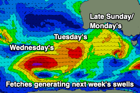
Looking at the larger developments into the middle of the week and Sunday's strengthening mid-latitude frontal progression will be ahead of a stronger polar low forming south-west of Western Australia on th e weekend.
The models were divergent regarding the strength and structure of the system but it looks like we have met half way. The polar low will generate a great fetch of severe-gale W/SW winds in our medium-range swell window, but as it moves under the country a great, elongated fetch of W/SW gales will be produced on top an active sea state, generating a more consistent, larger mid-period swell.
Timing wise, the mid-period energy will arrive just ahead of the longer-range groundswell but both should peak through Wednesday across the state. On Tuesday we'll see some fresh mid-period SW swell from a front just ahead of the low passing under the state Monday and this should provide better 3-4ft sets across Middleton-Goolwa with the Mid Coast dropping back to 1-2ft.
The large energy on Wednesday should come in at 5-6ft across Middleton with the odd bigger set on the deep water reefs. The Mid looks to offer fun 2ft sets on the favourable parts of the tide.
Now, locally winds on Tuesday look light out of the W/NW early (possibly variable on the Mid but we'll review this Monday) with winds shifting SW-S/SW through the morning. Wednesday looks cleanest on the Mid with morning SE winds ahead of sea breezes with the South Coast possibly seeing lighter E'ly winds, though it won't be ideal.
Unfortunately a high pressure system will start to move in Thursday bringing S/SE winds as the mix of swells ease with lingering S/SE winds into Friday. Therefore while not ideal for the South Coast there should still be OK waves while the Mid will be much smaller but cleaner. Check back on Monday for the latest on these swells. Have a great weekend!


Comments
Awesome, some good swell on the way but need to work around the winds :-)