Fun weekend down South with bumpy, workable waves on the Mid
South Australian Surf Forecast by Craig Brokensha (issued Friday July 30th)
Best Days: Mid Coast tomorrow afternoon and Sunday, South Coast Saturday, Sunday and Monday morning
Features of the Forecast (tl;dr)
- Low point in swell tomorrow morning ahead of a building, mid-period W swell into the PM. Fresh N/NW tending W/NW winds down South, moderate to fresh N/NE tending moderate W/NW winds on the Mid
- Inconsistent WSW groundswell for Sun with moderate NW winds down South, tending N/NW late and light to moderate N/NE tending N/NW on the Mid
- Strengthening N tending NW and then W winds Mon with an easing W/SW groundswell
- New mid-period W/SW swell for Tue but with strong W-W/SW winds
Recap
Wednesday's large stormy swell on the Mid eased back to the 3ft range on the sets yesterday with a bit of an improvement in conditions with a cross-shore N'ly wind but it was still bumpy and choppy. The South Coast was the pick with great conditions and 4-5ft waves across Middleton, easing through the day and back to 3ft this morning with lighter offshore winds.
The Mid Coast was a bit cleaner again this morning though still bumpy with peaky sets to 2ft.
This weekend and next week (Jul 31 – Aug 6)
We'll see the surf continuing to ease to a low point tomorrow morning across both coasts, ahead of a new mid-period W'ly swell into the afternoon, and better W/SW groundswell Sunday.
Winds will be fresh from the N/NW on the South Coast creating clean conditions with smaller 2ft waves across Middleton, bumpy and 1-2ft on the Mid with N/NE tending W/NW winds, though without much strength into the afternoon.
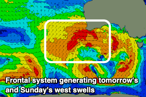
 Looking at the afternoon increase in mid-period W'ly swell, and this is being generated by a significant polar storm that projected up from the Heard Island region, towards and then across Western Australia.
This frontal system is now dipping south-east while moving in from the west, aiming strong to gale-force W winds in our western swell window, with the fetch weakening while moving in from the west this evening.
Size wise, the Mid Coast should build to 2-3ft mid-late afternoon tomorrow and with that moderate, workable W/NW breeze and the South Coast should kick to 3ft but with moderate to fresh W/NW winds.
Now the initial stages of this significant storm will generate a less consistent but stronger W/SW groundswell for Sunday, with infrequent though good 3-4ft+ sets due across the Middleton stretch and to 3ft on the sets across the Mid Coast.
Winds will improve on the South Coast during the day with a good, morning NW offshore due to swing more N/NW late afternoon, while the Mid Coast should see light dawn N/NE winds, shifting NW through the day but without too much strength.
As we move into Monday, winds will strengthen out of the N'th, shifting NW and then W as a strong mid-latitude low pushes in from the west.
Size wise, Sunday's swell will be on the ease with easing 3ft waves across Middleton, 2ft+ on the Mid Coast and with choppy conditions. We may see some late increase in windswell on the Mid, but Tuesday is a better chance for this, mixed in with a new mid-period W/SW swell.
The groundswell will be generated by the earlier stages of the mid-latitude front, with it being a polar front, projecting up and into Western Australia today and tomorrow.
The Mid Coast should come in at 2ft to occasionally 3ft on Tuesday, with the South Coast seeing inconsistent 3ft+ sets across Middleton, but with strong W-W/SW winds, limiting surfing options. Wednesday may see more favourable W/NW winds in the morning, but we'll review this on Monday.
Longer term there's nothing too significant on the cards until the second week of August, with a temporary relaxation of the mid-latitude frontal activity. Check back here on Monday for the latest though and have a great weekend!

