Fun weekend down South, great Monday
South Australian Surf Forecast by Craig Brokensha (issued Friday April 16th)
Best Days: Keen surfers Friday, beaches Saturday morning, keen surfers Tuesday and Fri
Features of the Forecast (tl;dr)
- New S/SW groundswell building this afternoon, easing out of the S tomorrow with a variable W/NW breeze down South, E/SE on the Mid
- Reinforcing S/SW groundswell for Sun PM and SW groundswell Mon with a W/NW-NW breeze Sun AM, strengthening N/NW tending NW Mon
- Significant SW groundswell for later next week from 'bombing' low
Recap
Plenty of swell on the Mid Coast yesterday but with a fresh onshore wind and generally average conditions, cleaner today and back to 1-2ft.
The South Coast was solid yesterday morning and with clean conditions in protected spots, easing back to 3-4ft this morning but with funky winds and a bit of drizzle. Conditions were cleanest towards Goolwa but with lots of duck diving.
Into this afternoon we should see a strong pulse of new S/SW groundswell from the polar front at the base of the mid-latitude low that moved through on Wednesday, with sets to 4-5ft due across Middleton as winds tend variable early afternoon ahead of a late, moderate S'ly.
This weekend and next week (Apr 17 - 23)
This afternoon's pulse of S/SW groundswell will be reinforced by a secondary S'ly groundswell tomorrow morning, generated by a great polar fetch drawn out and up behind the mid-latitude low linked to our W/SW swell Wednesday/Thursday.
Sets to 4ft+ are still due across Middleton early, easing steadily through the day with the Mid Coast dropping back to 1-1.5ft.
Winds look favourable and variable, tending W/NW on the South Coast tomorrow morning, E/SE on the Mid ahead of afternoon SW-W/SW winds. The swell will drop temporarily early Sunday but likely not below 3ft across Middleton ahead of some good new S/SW groundswell into the afternoon. Winds should be W/NW-NW in the morning (variable on the Mid) ahead of sea breezes.
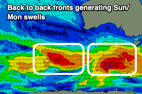
 The source of the afternoon swell and a secondary SW pulse for Monday will be back to back strengthening cold fronts that are currently pushing in under the country.
The first now looks to be the strongest, but with the second acting on the active sea state from the first, both pulses should come in around a similar size.
Currently a great fetch of W/NW-W/SW gales are being generated through our south-western swell window, almost reaching severe-gale strength. This will produce an initial pulse of S/SW Sunday afternoon to 3-4ft across Middleton, holding Monday. The swells will be too south for the Mid and only to 1ft+.
Winds will be great Monday and this looks the pick of the two swells with a moderate N/NW offshore, strengthening from the NW into the afternoon, while a cold front will bring a strong W/NW tending S/SW breeze by late morning.
This front won't bring any considerable swell with it due to be superseded by a much more significant storm.
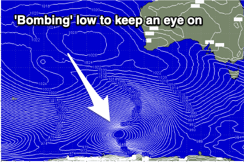
 Looking at the significant storm firing up next week, and we're looking at another 'bombing' low. The catalyst will be a strong low that's due to form off the South African coast today (south of Madagascar) forecast to track east on the weekend before being reabsorbed into the westerly storm track.
We'll see the low drop significantly in central pressure south-southwest of Western Australia, generating a fetch of severe-gale to storm-force W/SW winds, weakening while projecting up towards us through next week.
This will generate a large, powerful, long-period SW groundswell for later next week but we'll take a closer look at this Monday. Have a great weekend!

