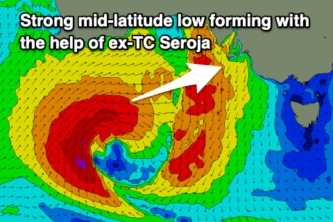
Seroja makes her presence felt in South Australia
South Australian Surf Forecast by Craig Brokensha (issued Monday April 12th)
Best Days: South Coast tomorrow morning, Mid Coast for the keen Thursday, South Coast Thursday morning, Mid Coast Friday morning, South Coast Saturday, Sunday and Monday mornings
Features of the Forecast (tl;dr)
- Easing S/SW swell tomorrow with strengthening N/NE tending N/NW winds
- Large W/SW groundswell building later Wed, easing Thu with strong W/SW winds Wed (W/NW for a period down South in the AM), W/SW winds Thu (W/NW in the AM down South)
- Easing W/SW swell Fri with S/SE winds on the Mid (S'th down South)
- New S groundswell Sat AM with NW tending W winds
Recap
An average start to the weekend with tiny, onshore waves on the Mid and a sloppy 2-3ft wave down South, best in protected spots for the keen early.
Sunday saw our oversized S/SW groundswell fill in with very large, though messy and generally poor waves across the South Coast, only surfable in novelty breaks, with average 1-2ft waves on the Mid Coast.
Today conditions are rapidly improving with a freshening offshore wind from the N/NE and large, easing sets from the 6ft+ range across the South Coast. The Mid Coast is clean but back to a tiny 1ft.
This week and weekend (Apr 13 - 18)
We've got a dynamic week of surf ahead as the remnants of Tropical Cyclone Seroja, which is currently tracking quickly south-east across the Western Australian wheat belt, due to combine with a mid-latitude low that's sitting south of Margaret River.
This will result in the further intensification and deepening of the mid-latitude low this evening, with it projecting a fetch of severe-gale W/SW winds towards us, through the Bight this evening and tomorrow before passing under us Wednesday.
 As the system pushes in tomorrow, we'll see winds become strong from the N/NE, shifting N/NW into the afternoon. Size wise the South Coast should still see 3ft sets across Middleton, but fading through the day with choppy N'ly windswell waves on the Mid Coast.
Wednesday will see strong W'ly winds as the low passes under us (W/NW in the morning down South), shifting W/SW through the day across both coasts. Size wise the morning looks small, but into the afternoon we should see a moderate-large W/SW groundswell from the severe-gale fetch filling in, building to 2-3ft on the Mid Coast by late, mixed in with local windswell and kicking to 4-5ft late in the day across Middleton.
Thursday morning will likely see similar sized surf across both coasts (more so 3ft on the Mid Coast), easing through the day but with lingering W/SW winds on the Mid Coast, better down South and W/NW through the morning.
A temporary low point (not below 3ft+) is due down south Friday, with the Mid Coast fading from 1ft to possibly 2ft, though a new S'ly groundswell may be seen later in the day, but peaking Saturday morning. Winds on Friday look average for the South Coast and fresh from the S'th, tending S/SE on the Mid in the morning.
 The source of this swell will be a strengthening polar front drawn up on the tail of the mid-latitude low, generating a fetch of gale to severe-gale S/SW winds in our southern swell window Wednesday evening and Thursday.
The South Coast should see a strong kick in size to 4-5ft Saturday morning across Middleton with a morning NW offshore, creating great conditions. We may even see winds hold all day from the W/NW as another front approaches, but more on this Wednesday.
Longer term there's plenty of further frontal activity on the way so check back Wednesday for the latest update.


Comments
Wtf..... what an amazing outcome Craig. A true autumn goodness compared to what we've had. Less westerly at this time of year but love it. Do you guys have future novelties on what's to come considering Victoria and Tasmania having snow at the moment?
Not sure where you guys are getting offshores from for Saturday?
Every wind forecast I can see is showing either w, sw or wsw?
Still moving about a bit, will have an update tomorrow. GFS as a morning W/NW-NW breeze, EC more light W-W/SW.