Slowly easing surf, large into the weekend
South Australian Surf Forecast by Craig Brokensha (issued Monday April 5th)
Best Days: South Coast tomorrow morning but more so Wednesday morning and Thursday morning on the magnets, Mid Coast for the keen tomorrow, South Coast early next week
Features of the Forecast (tl;dr)
- Slowly easing SW tending S/SW swell over the coming days with an E/NE breeze tomorrow AM, NE Wed AM, N/NW Thu AM
- Large S/SW groundswell for Sun with fresh S/SE-SE winds, easing early next week with E/NE-NE winds Mon, N Tue
Recap
Tiny, teaser waves on the Mid Coast most of the weekend before kicking a little yesterday afternoon and evening with the arrival of a new W/SW and SW swell combo. Conditions were clean through the mornings ahead of sea breezes.
Today we've got a peak in SW swell energy with good, clean 2ft waves on the Mid Coast and bumpy, workable 3-4ft sets for the keen on the South Coast.
This week and weekend (Apr 6 - 11)
The frontal progression linked to the increase in swell yesterday which is peaking in size and energy today has since left our swell window, and as a result we'll see the swell easing in size over the coming days. It will be slowed by continued, less favourable polar frontal activity though, generating reinforcing energy through the coming days.
One such system is south-west of us, producing strong to gale-force W/NW winds late in our southern swell window.
Easing surf from 3-4ft is expected across Middleton tomorrow morning ahead of a peak in energy this afternoon, 1-1.5ft on the Mid Coast. Wednesday looks smaller with tiny waves on the Mid, easing 3ft sets across the Middleton stretch (mostly 2-3ft).
Winds will slowly improve with an E/NE breeze down South tomorrow morning ahead of sea breezes, E/SE tending S/SE on the Mid, best Wednesday with a NE offshore ahead of sea breezes. Thursday will be cleaner again with a light N/NW offshore, giving into a late SW change but the swell will be smaller and back to 2ft across Middleton.
Thursday's change will be brief, with winds shifting back to the S/SE on Friday along with a new, building, mid-period S/SW swell from the front linked to the change. Size wise nothing major is due with building surf to 3ft across Middleton late in the day, easing Saturday from a similar size with lingering S/SW winds. Unfortunately the swell will be too south to impact the Mid Coast.
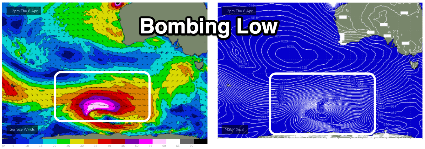
Looking at the outlook for the rest of the weekend and we've got a significant, 'bombing low' on the cards later this week, forming east of the Heard Island region. A 'bombing' low is one that drops 24hPa or more within 24 hours and this will drop about 34hPa from Wednesday afternoon to Thursday afternoon.

This will see a fetch of storm-hurricane force W'ly winds firing up along the polar shelf, projecting east and then north-east, up and across Tasmania on Saturday.
A large, long-period and consistent S/SW groundswell will be seen, filling in Sunday and peaking to an easy 6-8ft across Middleton with 8-10ft sets on the deep water reefs, though likely only 1-2ft with the southerly direction on the Mid Coast.
Unfortunately winds will remain poor and onshore, out of the S/SE-SE and fresh, favouring the Mid Coast, likely tending around quickly to the E/NE-NE on Monday morning as a high moves in along with moderate-large easing surf.
Tuesday looks excellent with N/NE offshores, but more on this in the coming updates.


Comments
Surfs up, will it get into Yorkes or mid coast? 12 ft south coast would be interesting...
Na. But head to pennington Bay for 15 onshore footer..
Chicken Run could be fun Sunday
Fun as in hot dog, chips and a coke deal?