Work the South Coast on the weekend, next week looks poor
South Australian Surf Forecast by Craig Brokensha (issued Friday March 5th)
Best Days: Tomorrow morning South Coast, Sunday until mid-afternoon South Coast, Mid Coast for the desperate Monday afternon and Tuesday
Features of the Forecast (tl;dr)
- New mid-period S'ly swell tomorrow with moderate E/NE-NE morning winds, easing Sun with a morning N/NE-NE breeze
- Inconsistent W/SW groundswell building for the Mid Mon, with a stronger SW groundswell Tue but with SE-S/SE winds
Recap
A weak swell with average E'ly winds across the South Coat yesterday morning, a bit bigger today but bumpier with a SE breeze. The Mid coast has remained unsurfable.
This weekend and next week (Mar 6 - 12)
After the run of fairly average and uninspiring conditions we're looking at a much better period of surf on the weekend for the South Coast with better winds and a fun S'ly swell.
Today's increase in mid-period S/SW swell is from a strengthening frontal system late in our swell window (currently moving across Tasmania), and we should see the best pulse of S'ly swell fill in tomorrow across the South Coast.
Winds will be moderate out of the E/NE-NE tomorrow morning, favouring selected locations and the new S/SW swell should come in at 3ft+ across Middleton, flat on the Mid Coast.
S/SE sea breezes are due by early-mid afternoon so surf before then.
Sunday will be cleaner with a light N/NE-NE offshore and sea breezes look weaker and later, tending S/SW as a trough approaches, stronger from late afternoon. The swell will be easing but a fun 2-3ft across Middleton.
Now, moving into Monday, an initial inconsistent W/SW groundswell is due to build across the Mid Coast, generated by a broad though distant storm firing up over the Heard Island region mid-week. This swell should build to a very inconsistent 1-1.5ft though not offer much down South.
Winds should be favourable and SE in the morning on the Mid Coast, stronger S/SE through the day though remaining relatively cross-shore.
The South Coast will be poor with the lack of swell.
 Our stronger SW groundswell for Tuesday is on track, with no real change to the expected size across the state.
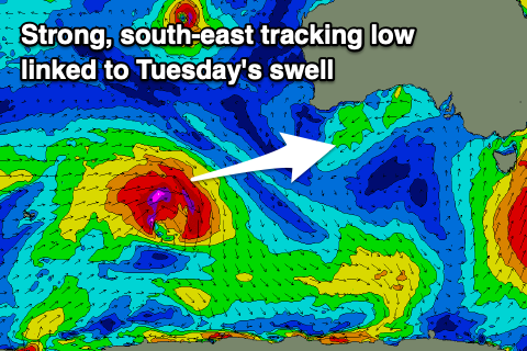
The low linked to the swell is currently south-west of Western Australia, generating a healthy fetch of severe-gale W/SW winds (in the Mid's swell window), but will dip south-east today while maintaining its strength. It should weaken slowly tomorrow evening before pushing east and breaking down south-west of Tasmania.
The swell will be a little inconsistent but should provide surf in the 1-1.5ft range on the Mid Coast Tuesday, with Middleton seeing strong 4ft sets (odd bigger 5ft'er at Goolwa) but with strong, persistent S/SE winds (SE in the morning on the Mid).
Winds will improve slightly Wednesday and swing E/SE as the swell eases from 3ft+ down South, tiny on the Mid Coast.
The surf will continue to ease into the end of the week with no further improvement in winds until Friday morning but we'll be looking at small to tiny waves across Middleton.
We will likely see a new mid-period SW swell for later Friday, peaking next Saturday with a NE offshore, but we'll have to have a closer look at this on Monday. Have a great weekend!

