Easing energy on the Mid Coast, poor down South
South Australian Surf Forecast by Craig Brokensha (issued Monday February 22nd)
Best Days: Mid Coast today, tomorrow and Wed AM, South Coast for the keen Tue AM and Wed AM
Features of the Forecast (tl;dr)
- Moderate to large W/SW groundswell building this afternoon with S/SW winds (S-S/SE on the Mid on dark), easing a touch Tue with morning E/SE winds on the Mid and possibly South Coast, smaller Wed with similar winds
- Good new S/SW groundswell for Sun but with strengthening S/SE winds
Recap
Fun waves all weekend on the Mid Coast with Friday's kick in initial W/SW groundswell holding around 2-3ft all day Saturday, helped by an additional W/SW pulse through the day, generated by a mid-latitude low under WA Thursday evening.
Conditions were generally favourable, with a bit more bump Sunday as the swell eased back to a slower 2ft or so. Today conditions are windy again with 1-2ft of swell, but a new W/SW groundswell should provide 2-3ft sets this afternoon though winds won't improve until right on dark.
The South Coast was average all weekend with no major size owing to the westerly swell direction and onshore winds.

New groundswell inbound
This week and weekend (Feb 23 - 28)
The good run of waves for the Mid Coast looks to continue over the coming days, but make the most of it as by Wednesday afternoon, we'll be on the backside and there's nothing significant from the west due to follow.
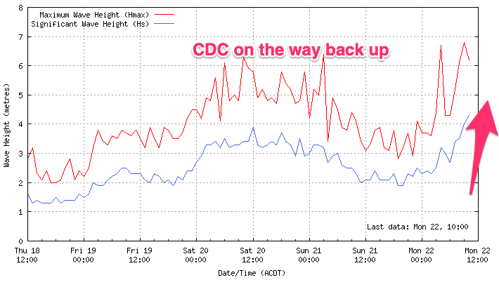
While the bulk of the long-period and strongest swell energy from the 'bombing' low is due to fill in this afternoon, we'll continue to see plenty of size tomorrow owing to the slow moving and prolonged nature of the storm.
The low weakened under the country on the weekend, but we still saw fetches of strong to gale-force W/SW winds projected through our western turning south-western swell window, with the system currently south of us, bringing today's S/SW winds.
We should see the kick in size this afternoon to 2-3ft on the Mid Coast and 4-5ft across Middleton (if not for the odd bigger one), ease back a touch into tomorrow morning with 2ft to occasionally 3ft sets and easing 4-5ft waves respectively across both coasts.
Conditions look great for the Mid tomorrow morning with an E/SE offshore, giving into sea breezes and then S/SE again later. The South Coast will remain onshore and bumpy, but winds may ease off for a period, offering OK conditions for the keen.
Wednesday will remain average down South with a moderate E/SE breeze, giving into afternoon S/SE breezes, E/SE tending SW on the Mid and then back to the S/SE late.
The swell will be on the way out though with easing 1-2ft sets on the Mid, dropping from 3-4ft across Middleton.
The end of the week doesn't look any better for the South Coast with the swell continuing to ease along with moderate S/SE tending S/SW winds Thursday, more variable from the SW on Friday morning but only 2ft or so across Middleton.
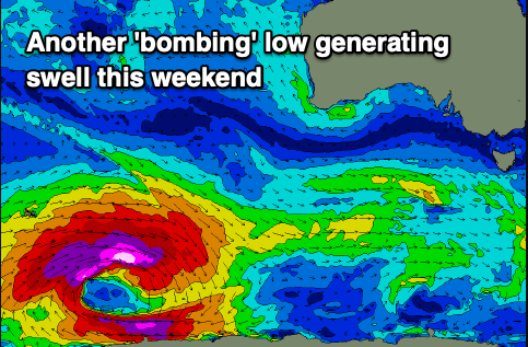
 Our new, long-period S/SW groundswell due this weekend (mentioned the last couple of updates) is still on track. The source of this swell will be another 'bombing' low around the Heard Island region, triggered by Tropical Cyclone Guambe, currently south-east of the South African coast, being absorbed into the westerly storm track.
As it does so it'll spawn a significant polar low, with a fetch of storm-force W'ly winds projecting through our medium-long range swell window as it tracks east-southeast.
The low will weaken south-southwest of WA mid-week, with the inconsistent, long-period SW groundswell energy due to build slowly late Saturday and peak Sunday to 3-5ft across Middleton, tiny and only 1ft or so across the Mid Coast.
Unfortunately winds look to be out of the S/SE all weekend, strong on Sunday, spoiling the South Coast. Longer term it looks like the sou-easters will become entrenched through next week, so make the most of the current and coming surf!

