A couple of slightly better swells for the Mid
South Australian Surf Forecast by Craig Brokensha (issued Monday January 11th)
Best Days: South Coast Wednesday morning, Mid Coast Friday
Features of the Forecast (tl;dr)
- Weak, building swell later tomorrow, peaking Wed with early variable winds ahead of a SW change
- Easing swell Thu with S'ly winds
- Better SW groundswell with some W/SW energy in the mix Fri with S/SE-S/SW winds
Recap
Very tiny, glassy waves on the Mid Saturday morning, near flat yesterday while the South Coast was the pick with light winds and improving conditions through Saturday, cleaner Sunday as the wind tended light offshore ahead of sea breezes.
Today a small lift in mid-period S/SW swell hasn't really amounted to much with clean, though small, inconsistent 1-2ft waves across Middleton, a touch better on the swell magnets.
The hot, freshening N/NW wind is associated with an approaching trough and this will bring a SW change early evening.
This week and weekend (Jan 12 - 17)
In the wake of this evening's change winds will be fresh out of the S/SE and without too much swell to start of the morning, but we'll see some new swell building into the afternoon.
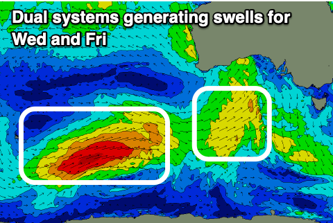
It'll be fairly weak swell generated today from a fetch of strong SW winds passing under WA, through the Bight, showing on the Mid Coast most noticeably through the afternoon with 1ft+ sets, while the South Coast will be a weak, choppy 2ft all day.
The bulk of the swell is due Wednesday though from the earlier stages of the front, when it was more at polar latitudes over the weekend, east of the Heard Island region.
 Size wise the swell looks a touch weaker than estimated on Friday with 1-1.5ft sets due on the Mid Coast on the favourable parts of the tide, with 2-3ft sets across Middleton. We're still looking at the window of variable winds in the morning ahead of another trough and W/SW-SW change late morning. So get in early for the best waves.
Moving into Thursday the swell will ease under S'ly winds in the wake of Wednesday's trough, while we've got a much better SW groundswell with a touch of W/SW energy in it due Friday.
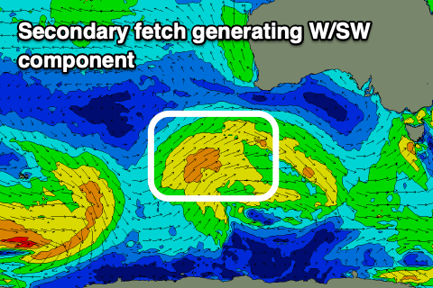
The source of this swell is a polar low that's formed around Heard Island, with a fetch of W/SW gales being projected east-northeast through our south-western swell window. As the storm projects east-northeast it'll weaken, with a weaker fetch of W/SW winds projected through the Mid's swell window, south-west of Western Australia.
 A mixed SW groundswell with some mid-period W/SW swell energy is due to arrive very late Thursday but peak Friday with fun 1-2ft surf on the Mid Coast and 3-4ft sets across Middleton-Goolwa.
Winds look to persist out of the S'th, tending S/SE for a period across the Mid Coast in the morning, S/SW through the day and S/SE again late. Saturday looks similar as the swell fades, tiny on the Mid Coast and bumpy down South.
Unfortunately S/SE-SE winds will persist through the weekend and early next week as a strong, slow moving high moves in from the west, blocking the Mid Coast's swell window again, while fronts skirting around the south-eastern corner of the high look to generate a couple of S/SW swells next week. More on this in Wednesday's update though.

