Large swell though onshore, improvement for the weekend

South Australian Surf Forecast by Craig Brokensha (issued Wednesday January 6th)
Best Days: Saturday, Sunday and Monday mornings down South, beginners on the Mid tomorrow
Features of the Forecast (tl;dr)
- Large S/SW groundswell tomorrow with fresh SE winds
- Easing, weakening swell on the weekend with light, favourable winds each morning
- Fun S/SW swell Mon with morning offshore winds
Recap
A continuation of poor, choppy surf with strong onshore winds across the South Coast (though with size), tiny to flat and wind affected on the Mid.
This week and weekend (Jan 7 - 10)
Later today we should see the forerunners of our large, strong, long-period S/SW groundswell filling in, with it hitting WA today, offering 6-8ft sets even when the low wasn't ideally aimed for the state, and formed late in their swell window. Keep an eye on the Cape du Couedic wave buoy for early indications.
There's no change to the expected peak tomorrow morning with 5-6ft sets due across Middleton (possibly odd bigger one exposed reefs), 1-1.5ft on the Mid Coast but with fresh and gusty SE winds, easing slightly for a period before strengthening into the afternoon from the S/SE.
The swell will ease through Friday but winds will remain average, easing though and lighter from the E/SE ahead of sea breezes. This easing trend will be slowed by a reinforcing mid-period S/SW swell generated by a trailing polar front moving in quickly on top of the strong low linked to the groundswell. Size wise Middleton looks to ease from 3-4ft, with tiny waves on the Mid Coast.
We'll see the surf continuing to ease in size and energy on the weekend and we're now looking at more variable and favourable winds for the South Coast with a light NE'ly Saturday morning, variable N/NE on Sunday. The swell magnets will be the pick with easing 2-3ft sets across Middleton Saturday morning, 1-2ft Sunday morning.
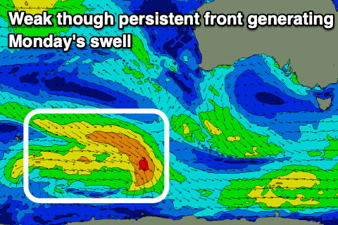 Into Monday, our new mid-period S/SW swell is on track, generated by a weak though broad and sustained polar front that's currently around the Heard Island region. A pre-frontal fetch of persistent strong W/NW winds, followed right behind by weaker W/SW winds should produce a fun kick in size Monday to an inconsistent 2-3ft across Middleton, tiny on the Mid Coast.
Conditions will be favourable again with a N/NE offshore, shifting N/NW ahead of a trough and S/SW change late afternoon, with Tuesday looking onshore as the swell eases.
Longer term there's nothing too major on the cards with weak mid-period swells (one possibly slightly better aimed for the Mid) due to continue along with S/SE winds, so make the most of the lighter winds on the weekend and early next week.
Comments
Still some 1-1.5 footers on the Mid Coast this morning, saw a slightly bigger set at Triggs too. Pretty much flat in between sets.