Large S/SW groundswell but with onshore winds
South Australian Surf Forecast by Craig Brokensha (issued Monday January 4th)
Best Days: Beginners Mid Coast Thursday, desperate surfers Friday morning, Monday South Coast
Features of the Forecast (tl;dr)
- Large S/SW groundswell for Thu, but with fresh SE winds, easing Fri with lighter morning E/SE winds
- Fun mid-period S/SW swell Mon with N winds
Recap
Poor surf all weekend down South with onshore winds and no swell with size or power, while today we've got an increase in local windswell from strong onshore winds and new mid-period SW swell. The quality remains extremely low though.
This week and weekend (Jan 5 - 10)
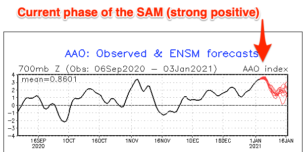
It's been a tough slog the past couple of weeks across the South Australian coastline, and we're at the peak of this positive Southern Annular Mode (SAM) event where the westerly storm track is pushed more polar, with high pressure dominating the mid-latitudes (bringing the S-SE winds).
The SAM is expected to weaken but remain positive over the coming week or two, and this will see the handle of the high pressure and onshore winds loosened a little but until early next week we're not looking at any true offshore flow across the state.

Looking at the coming two days and after strong S/SE winds kick in this afternoon we'll see them ease off a little tomorrow, though remain gusty from the S/SE with a mix of easing mid-period swell and localised windswell.
Wednesday won't see any improvement unfortunately with fresh to strong S/SE winds continuing.
Later in the day Wednesday we may see signs of our new, long-period S/SW groundswell building across the South Coast, but a peak is still slated for Thursday morning.
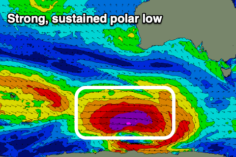
The strong polar low linked to the swell has developed and it's now positioned south-southwest of WA with a broad and elongated fetch of severe-gale to storm-force W'ly winds currently being generated through our south-western swell window.
 The low will continue east while weakening only slightly today, breaking down more so through tomorrow, though a smaller polar front will slide in behind the low, generating an additional fetch of W/NW gales through our southern swell window.
With the sustained fetch of severe-gale to storm-force winds, a large, long-period and powerful S/SW groundswell is due across the state, with the kick later Wednesday likely to see sets push to 3ft across Middleton by dark, peaking Thursday to 5-6ft. Deep water reefs are due to offer larger surf, while the Mid Coast doesn't look to really top 1-1.5ft on the favourable parts of the tide owing to the southerly direction.
Unfortunately we'll continue to feel the wrath of the strong high that'll try and slowly move east with fresh SE winds Thursday morning, stronger from the S/SE into the afternoon, possibly lighter E/SE Friday morning as the swell eases back from the 3-4ft range across Middleton.
The weekend doesn't look any better with the swell due to continue easing with light SE winds Saturday morning, possibly more variable Sunday morning but with small 2ft leftovers across Middleton.
Into next week, we should finally see winds swing offshore out of the N/NE tending W/NW on Monday as an inland surface trough pushes east across us. This will only be short-lived though so make the most of it.
The offshore winds will coincide with a fun, new mid-period S/SW generated by a weak though broad and sustained polar front developing around the Heard Island region Wednesday.
The size from this front looks healthy with Middleton coming in around 2-3ft, tiny on the Mid Coast. Tuesday looks smaller as S/SE winds blow in the wake of the trough.
Longer term there's nothing significant on the cards for the rest of the week, but more on this Wednesday.


Comments
A shocker of a run like this makes you think a wave pool would be a pretty good thing!
Have you guys noticed the water cool with upwelling from this run of winds?
Not sure too many of us have been in the water lately Craig haha. Been one of the worst runs i can remember
Ha, true!
I was in the water 2-3 times a day 27 Dec - 3 Jan down south. Still waves to be had!
I found it cooler than normal for this time of year. But that could also have been from the shitty weather. Cold winds in the morning and air temps generally quite low.
I went in the water on New Year's Day to give some tips to a mate's son who got a board for Christmas and is a little frother. 20-30km/h onshores, but the water was toasty compared to what I'm used to down here. Still in that two week period when you can actually wear boardies and rashie in SA and not get hypothermia.
It finally swings offshore on Monday which is first day back at work after being off since the 22nd Dec. Seriously fuck you Huey. Lol!
Unprecedented?
Nah, it gets this shit every summer at some stage.
Probably not. And hopefully never repeated. Huey I dunno where the fuck you've gone on holidays but you're needed back home asap
ben/craig , can you give us a low down on la niña and what we are likely to expect in south oz ..? all the info i’ve found is for northern australia and east coast but not much for south oz ...
cheers
Unfortunately the link to swell from La Niña/El Niño for South Australia isn't as quantifiable as it's a Pacific Ocean phenomena, hence influencing the East Coast.
In saying + SAM events are a feature of La Niña years, and this isn't great for South Aus as you're currently experienced. The sub-tropical high blocks swells and brings south-east winds.
cheers craig , relentless hey , next couple days could be ok ...
I have still had waves down south, just can't be picky and there have been a few windows when the winds have been light and the faces clean. If you wait till it cleans up proper you wouldn't be surfing for a month! The water temp has been pretty good and easily handled in a 2mm short arm steamer.
No surfing for a month? Ha, luxury! When I was a boy...
They don't call me Surfstarved for nuthin'