Poor winds spoil the South Coast
South Australian Surf Forecast by Craig Brokensha (issued Wednesday December 30th)
Best Days: Keen surfers Saturday morning
Features of the Forecast (tl;dr)
- Poor S/SE windswell developing tomorrow, easing Fri with a slight easing of winds in the PM
- Cleaner Sat morning but on the small side
- New mid-period SW swell for Mon but with strong S/SE winds
- Possible larger groundswell mid-late week
Recap
A drop in swell from Monday afternoon across the South Coast yesterday morning with light winds, kicking into the afternoon again with a fresher onshore breeze. Today's bumpy and average with the small swell.
The Mid Coast was tiny in the morning, though kicked to 1-1.5ft through the afternoon but with fresh sea breezes, cleaner again today but also tiny. The afternoon should see a pulse back to 1-1.5ft again
This week and next (Dec 31 – Jan 8)
One look at the forecast charts for the South Coast region tells the story. Non-stop and at times strong S-SE winds.
The reason for this, as touched on in the last couple of week's notes is a strong positive Southern Annular Mode, keeping the westerly storm track contracted to the pole as high pressure dominates the mid-latitudes, bringing the south-east wind regime.
These winds are favourable for the Mid Coast but with the storm track to the south, there's no decent westerly energy available.
We'll see any tiny swell seen this afternoon on the Mid fading tomorrow and the South Coast will be poor with fresh SE winds, strengthening from the S/SE into the afternoon. This will kick up a low quality S/SE windswell to 3ft+ later (2-3ft in the morning), easing from 3ft Friday morning.
Winds are forecast to relax and swing lighter E/SE on Friday morning but after all the onshore wind tomorrow and into the evening, conditions will be average, sloppy and only for the super keen.
Saturday looks to offer variable winds early though small, easing surf from 2ft across Middleton, while the afternoon will deteriorate as a trough moves in from the west, bringing freshening S/SW winds.
Sunday may see a light morning SW breeze but the surf looks to remain average, with no new decent swell.
 As we move into next week we'll see a new high push in behind the weekend's trough, bringing strong S/SE winds Monday, spoiling our new mid-period SW swell.
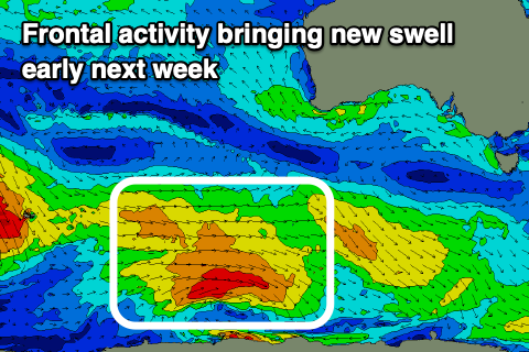
The source of this swell is a polar frontal progression that developed around the Heard Island region last night, pushing east while generating a fetch of strong to near gale-force W/SW winds over the coming days. It won't be overly strong but the swell should arrive overnight Sunday, peaking Monday to 3ft across Middleton (mixed in with some new S/SE windswell) and 1ft on the sets across the Mid Coast.
Tuesday looks similar in size with a reinforcing mid-period swell from a secondary trailing polar front, though winds look to persist from the S/SE, moderate to fresh in strength.
Longer term, unfortunately we look stuck with the winds from the south-eastern quadrant, but a couple of stronger polar storms developing south-west of Western Australia should produce some better, long-period groundswell mid-late week. We'll have a closer look at this on Friday though and any hint of better local winds (possibly Friday).


Comments
if south easterly was a bloke i’d legit punch him so hard in the throat
Ha, though as mentioned last notes, as we all know.. tis the time of year.
Not much joy for the next week or two but it looks like the the SAM may be turning the corner - https://www.cpc.ncep.noaa.gov/products/precip/CWlink/daily_ao_index/aao/...
South coast has been a bit of fun the past few days if you adjust your standards for the time of year