Dreaded sou'easters
South Australian Surf Forecast by Craig Brokensha (issued Monday December 28th)
Best Days: Keen surfers South Coast tomorrow morning, Mid Coast for the keen tomorrow morning and Wednesday, South Coast Saturday morning
Features of the Forecast (tl;dr)
- Small, weak mid-period W/SW-SW swell for Tue/Wed, clean each morning on the Mid (OK Tue AM down South)
- S/SE windswell for late week with onshore winds, lighter Sat AM
Recap
Peaky, lumpy waves across the South Coast Saturday morning with fun 2-3ft sets across Middleton, easing through the day, tiny into Sunday as the swell faded along with a morning change. The Mid Coast offered nothing of substance with tiny to flat surf.
Today some new mid-period swell has filled in across both coasts, coming in a bit better and earlier than expected with 1-2ft sets on the Mid Coast, 2-3ft down South but with onshore winds.
This week and weekend (Dec 29 – Jan 3)
We've got a fairly weak, average week of waves ahead, but the Mid Coast will provide tiny pulses of swell for the keen while the South Coast looks mostly onshore.
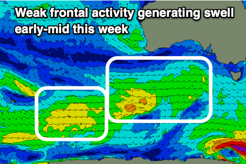
 The front linked to today's swell is being backed up by a couple of similar, weak frontal systems with fetches of strong W/SW winds moving through our western/south-western swell windows.
As a result the Mid Coast is likely to persist around 1-1.5ft on the favourable parts of the tide tomorrow and Wednesday, tiny Thursday. The South Coast looks to be on the small side and 2ft to occasionally 3ft across Middleton tomorrow and Wednesday morning, easing thereafter.
Looking at the local winds and a light SE offshore is due on the Mid tomorrow morning, light S'ly down South creating workable conditions, shifting SW into the afternoon. SE winds are then due again Wednesday, moderate in strength across both regions, and fresher S/SE into the afternoon.
As touched on last week, a deepening inland surface trough squeezing a strong high to our south will see winds strengthen from the S/SE on Thursday, stronger into the evening.
This will whip up a stormy S/SE windswell down South, though light to moderate E/SE winds on Friday morning may offer a window for a surf. Size wise the windswell looks to reach 3ft+ late Thursday, easing from a similar size Friday morning, smaller Saturday as the windswell fades with morning variable winds. The Mid Coast isn't expected to offer any size, though a very inconsistent long-range W/SW groundswell should keep 1ft sets hitting the region Thursday and Friday.
Longer term a new inconsistent SW groundswell is due Monday, produced by a broad, though distant polar frontal progression east of Heard Island, but winds look to persist out of the S/SE all week, creating poor conditions down South. More on this in Wednesday’s update though.


Comments
summer southerlies locked and loaded
Shows how lucky you guys were in October/November eh.
yeah oct / nov and early Dec were all very good and majorkong made the most of it... stellar surf conditions will return... and like Alfred E. Neuman said "what, me worry?"
This forecast is exactly what we should have expected to finish 2020. What an utter poostorm of a year.
This forecast is actually normal for summer and traditionally summer is not great conditions predominant SE winds
Happy holidays, not
Just jumping the fence here for a second, but yes, howling howling SE here on the WA sth coast too. Just basically got raped by the wind for the last 3 hours down the beach. But we had it good for so long so all good! The longer it goes on the sooner it ends right!!
What are the favourable times of the tide when you are talking about the Mid?
Without giving up too much, the Mid Coast is influenced heavily by the incoming and outgoing tides flowing through the gulf and also Investigator Strait. One will help push the swell a little, the other will hold it back.
May have seen something in triggs cam around 1055 am top right?bob the bronzie
Hmm, can't see anything in the replays?