Strong W/SW groundswell event incoming
South Australian Forecast by Craig Brokensha (issued Wednesday 18th November)
Best Days: Mid Coast at certain times tomorrow, South Coast until the change hits, Mid Coast Friday, South Coast Saturday morning
Recap
Clean conditions across both coasts yesterday with the swell dropping back to 1-2ft on the Mid Coast and easing from 2ft across Middleton with decent winds most of the day.
Today both coasts are a touch smaller and generally tiny with the exposed swell magnets down South the pick.

Tiny peelers today
This week and weekend (Nov 19 - 22)
Following the low point in swell today, we've got our strong, large, long-period W/SW groundswell event due to fill in tomorrow, from a 'bombing low' forming in our swell window Monday.
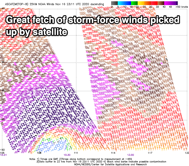
 The low (which originated from a surface trough) dropped more than 24hPa in a 24 hour period classifying it as a 'bombing low' resulting in a fetch of severe-gale to storm-force W'ly winds developing in our western swell window.
Satellite passes of the low have picked up an impressive swathe of purple, storm-force (50kt+) winds, with the low weakening slowly yesterday but still maintaining a fetch of gale to severe-gales in our swell window.
The storm is pushing slowly east today while weakening further but still maintaining a fetch of strong W'ly winds in our south-western swell window.
The slow movement of the low and longevity will translate to a prolonged groundswell event, initially west in nature and swinging more south-west through Friday and easing Saturday.
The groundswell is due to arrive early tomorrow morning, kicking strongly through the day and peaking into the afternoon. There's no change to the expected size with the Mid Coast starting slow but kicking to 2-3ft into the afternoon, though there isn't expected to be much of an incoming tidal push, while the South Coast should see 3-4ft waves off Middleton Point, with 4-5ft sets towards Goolwa, (small 2ft early).
Winds are tricky tomorrow and both coasts should see windows of quality surf.
The Mid Coast will become bumpy and choppy with fresh to strong N/NE winds through the morning, but a shift to the NW early afternoon and shallow, weak S/SW change into the mid-late afternoon should offer a window of good surf with the drop in wind strength. Late winds will go strong SW creating poor conditions.
The South Coast will be windy with strong N'ly winds, shifting N/NW late morning and W/NW-NW early afternoon ahead of a late afternoon and strong SW change.
Friday will be best on the Mid Coast with a moderate S/SE breeze and drop in swell back to 2ft, with the South Coast easing from the 4ft range across the Middleton stretch. Afternoon sea breezes will be seen on the Mid, but back to the S/SE late in the day.
Come the weekend the South Coast will be the pick as winds swing more NE owing to a high moving in from the west, along with easing surf from a smaller 2ft+ across the Middleton stretch. The Mid Coast will become tiny, with a low point in swell due across both coasts Sunday morning under a N/NE offshore.
Into Sunday afternoon a new, inconsistent mid-period W/SW should start to build, generated by a relatively weak cold front north-east of the Heard Island region. This front will weaken south-west of WA tomorrow, leaving an inconsistent, small, mid-period W/SW swell to travel towards us, kicking to 1-2ft on the Mid Coast Sunday afternoon and 2ft+ down South.
A surface trough unfortunately looks to bring a SW change Sunday afternoon, with stronger W/SW winds possibly in its wake Monday, but more on this and a possible stronger frontal progression developing through next week in Friday's update.


Comments
Seems we can't surf anyway for the next 6 days :(
Bummer.
Few sneakers for the last supper..
Not much panic surfing going on at Triggs, even though it's looking bloody lovely, 31 degrees, light winds and a clean groundswell. Five blokes out!
Next minute.
Yeah, they were all at the Waits Point carpark (or in the water). It was a bloody circus yesterday!
if you suffer from anxiety dont stare at the cams for the next 2,3 days
If it's any consolation we weren't allowed to surf for five weeks here back in March/April. You'll come out of it frothing like grom.
Had an awesome arvo session on the mid this arvo on turn of the tide. Thankful for great conditions and the ability to get away from work early before the impending 6 day lockdown. Hopefully we can get the current outbreak under control quickly so we can all get back in the surf again soon. Stay safe all South Aussies. :)
Don't know what everyone else thinks. But do you think no surf reports for the time off?
We went through this at length back in March, when Covid-19 initially started to become an issue. It's also been debated at length during the Vicco lockdowns.
In short, surf reports will remain as is (where it's safe for our reporters to do so).
All good
old mate bodyboarding out at Christies atm