Upgrade in coming swell with tricky winds

South Australian Forecast by Craig Brokensha (issued Monday 16th November)
Best Days: Both coasts tomorrow AM, Wednesday morning South Coast magnets, Thursday both coasts, Friday Mid Coast, Saturday morning South Coast
Recap
Tiny waves on the Mid Coast Saturday, cleaner and fun down South with a drop in swell back to 2ft across Middleton on the sets.
Our new W/SW groundswell filled in Sunday with tiny, bumpy waves on the Mid Coast through the morning, building to a fun 2ft with the incoming tide along with workable winds for the keen as a shallow change moved through.
Today the swell is still 2ft but choppy with a fresh onshore wind, bumpy, small and average down South.

Yesterday's fun pulse
This week and weekend (Nov 17 - 22)
Today's choppy and bumpy conditions are due to a mid-latitude frontal system pushing in and clipping the south of the state.
A weak mix of W/SW windswell and mid-period energy is due tomorrow and Wednesday from this and another weak front that's under WA with small 1-2ft sets due down South across Middleton both days, 1-2ft on the Mid tomorrow, tiny Wednesday.
Winds tomorrow are due to be light offshore across both coasts in the morning, NW down South and SE on the Mid, giving into afternoon sea breezes.
Wednesday will see fresher NE winds develop shortly after dawn, variable NW into the afternoon.
We then look at the new W/SW groundswell due Thursday, generated by a strengthening mid-latitude front south-west of Western Australia today.
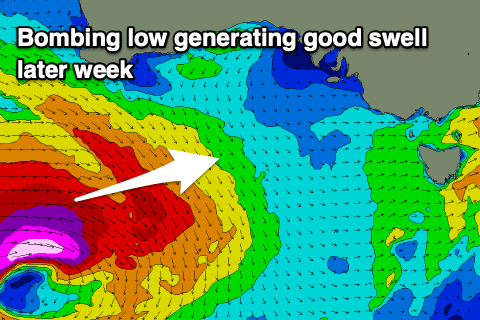 I mentioned to keep an eye on this system and those who have, would notice that it's now forecast to be significantly stronger with it 'bombing' and dropping in more than 24hPa of central pressure in 24 hours. It'll actually bottom out at 941hPa.
The low was a surface trough yesterday but today it's deepening significantly and with this we'll see a great fetch of pre-frontal severe-gale W/NW winds followed by severe-gale to storm-force W/SW winds through our western swell window, south of WA through this evening and tomorrow morning.
The low will weaken tomorrow while tracking slowly east-southeast, but we'll still see a fetch of W'ly gales generated through our south-western swell window, prolonging the swell event through Friday.
What we should see is a moderate to large, long-period W/SW groundswell arriving overnight Wednesday and building strongly Thursday ahead of a peak into the afternoon.
The Mid Coast should kick to a good 2-3ft though the tides aren't too favourable for the afternoon kick, easing back from 2ft Friday morning.
The South Coast should build to 3-4ft off Middleton with 4-5ft sets towards Goolwa on Thursday afternoon, easing from the 4ft range Friday but only slightly owing to the longevity of the low.
Looking at the local winds an an approaching trough will bring strong N/NE winds, shifting N/NW late morning ahead of an onshore change into the afternoon which will be strong into the evening out of the SW.
Friday will be a day for the Mid with S/SE-SE winds ahead of SW sea breezes, back to the S/SE late.
A high will move in on the weekend, swinging winds E/NE-NE on Saturday while a trough might bring a shallow change Sunday (we'll review this on Wednesday). Size wise the swell will be easing and from a SW direction leaving tiny waves on the Mid and easing 3ft sets across Middleton, tiny Sunday.
Longer term a small W/SW swell is likely early next week, but more on this Wednesday.