Winds limit squeezing the most potential of the swells
South Australian Forecast by Craig Brokensha (issued Friday 30th October)
Best Days: Keen surfers on the Mid Coast working the tides tomorrow, desperate surfers South Coast Sunday morning, Mid Coast for the keen Thursday afternoon, Friday morning down South
Recap
Clean though tiny waves on the South Coast yesterday morning with nothing surfable on the Mid early. A new W/SW groundswell filled in with localised windswell on the Mid Coast through the afternoon along with onshore winds, poor down South as winds strengthened from the W/NW.
Today we've got a peak in strong W/SW groundswell and consistent sets to 2ft across the Mid Coast but with less than ideal conditions, poor, sizey and a mess down South.


This weekend and next week (Oct 31 - Nov 6)
Today's W/SW groundswell will ease slowly through the weekend and winds will favour the Mid Coast tomorrow, improving for the South Coast Sunday.
Size wise we've be back to a slower 1ft to occasionally 2ft across the Mid Coast on the favourable parts of the tide. It'll be average early with the big high tide and not the greatest as it recedes either. Winds should hold out of the S/SE all day though creating favourable conditions.
Sunday will become tiny, and the South Coast should see a morning E/NE-NE breeze, though size wise we'll be looking at small, fading 2ft sets across Middleton.
 Monday looks nice and clean but the surf fading from 1-2ft across Middleton with a moderate to fresh N/NE breeze.
Pencil in lay days for Tuesday and Wednesday as the swell bottoms out on the former and a S/SW change moves through on the latter.
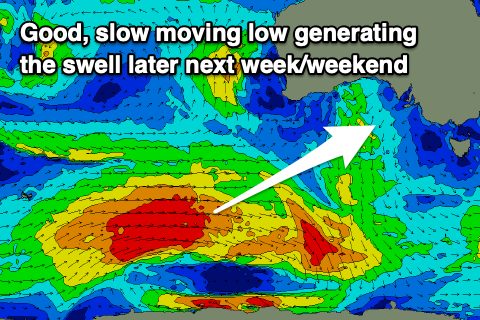
Looking at the slow moving polar storm that's due to develop this weekend and the intensity has been backed off just a touch but the longevity increased as it edges closer towards us early next week.
The low will form in our far swell window, generating a good, slow moving fetch of W/SW gales, pushing further east while slowly weakening Monday but persisting through Tuesday.
This should create an inconsistent, moderate sized SW groundswell event that'll be prolonged but lose power on the back end owing to the weakening of the fetch as it moves closer towards us.
Unfortunately as the bulk of the swell fills in Thursday, peaking to 4ft across Middleton and 1ft to possibly 2ft on the Mid, a trough will bring a SE change, favouring the latter. We may see winds swing back offshore Friday morning for the South Coast as the swell starts to slowly ease, but more on this Monday.
Longer term there's follow up swell activity into the following weekend and early the next week with winds from the south-east, though check back Monday for the latest. Have a great weekend!

