Average weekend owing to the lack of size, larger and windy next week

South Australian Forecast by Craig Brokensha (issued Friday 14th August)
Best Days: South Coast magnets for the desperate Monday morning, stormy waves Wednesday
Recap
A very slight lift in swell on the South Coast yesterday though mostly tiny, a bit better today and to 1-2ft across Middleton with a light offshore wind. The Mid Coast saw bumpy 2ft waves yesterday, a bit cleaner today though back to 1-2ft.
This weekend and next week (Aug 15 - 21)
The coming weekend isn't too special at all, either is the outlook for early next week.
A weakening mid-latitude low is moving in from the west and this will shift winds to the west later today, with tomorrow seeing W/NW tending W/SW breezes with minimal amounts of swell. The Mid Coast looks tiny and to 1-1.5ft, with 1ft to possibly 2ft sets from Middleton to Goolwa.
Similar winds and sized surf is expected on Sunday, while the Mid Coast will drop further in size.
There's no new swell due into Monday but winds will shift back to the north, fresh N/NE tending N/NW as a mid-latitude low starts to move in from the west.
The models are starting to converge regarding the swell generating potential from this low, with it expected to drop under WA's south coast on Sunday and into our western swell window.
 All the swell generating fetch will be mostly aimed towards the Mid Coast, with Kangaroo Island shadowing a lot of the South Coast, limiting the size.
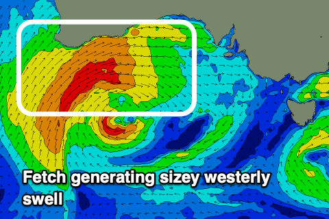
An initial burst of W/SW gales Sunday afternoon and evening should produce a spike of swell for Tuesday, followed by a broader fetch of strong to gale-force W/SW winds which will then project east and into us on Wednesday. This will bring a large W/SW groundswell and local stormy swell for the Mid Coast.
Size wise, a kick to 2ft is likely Tuesday on the Mid Coast (remaining tiny down South) while Wednesday looks to see stormy waves possibly reaching 3-4ft (2-3ft across Middleton). Winds will accordingly strengthen from the NW tending W/NW on Tuesday and then strong to gale-force Wednesday, though we'll have to review the timing of this as the models diverge slightly.
We'll likely see continued frontal activity into the end of the week as polar fronts push up in the wake of the mid-latitude system bringing more size for the South Coast but also onshore winds. More on this Monday. Have a great weekend!