Westerly swells followed by a tricky and stormy outlook next week

South Australian Forecast by Craig Brokensha (issued Wednesday 29th July)
Best Days: Both coasts tomorrow and Friday, early Saturday Mid Coast - South Coast all day, both coasts Sunday, Monday early South Coast
Recap
Good waves across both coasts yesterday morning with a new W/SW tending SW groundswell with variable winds and improving conditions down South to 3ft off Middleton, clean and to 1-2ft on the Mid Coast magnets through the morning.
Today the swell has eased leaving 1-1.5ft sets on the Mid Coast with bumpier conditions, better down South and to 2ft off Middleton.
This week and weekend (Jul 30 – Aug 2)
As touched on in Monday's update, from tomorrow we'll see various pulses of W/SW groundswell across the state, generated by a progression of mid-latitude frontal systems moving in from the Indian Ocean and under the country.
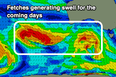 One of these systems which was quite strong and significant in the Indian Ocean is now weakening while pushing in and under WA and the swell from this should build through tomorrow and kick to 2ft across the Mid Coast on the sets and reach 3ft+ across the Middleton stretch, though inconsistent.
A slight drop in size is due Friday down South to 3ft across Middleton, an inconsistent 2ft on the sets across the Mid Coast, while some new W/SW groundswell is due to fill in Saturday.
The source of this will be pre-frontal W/NW gales moving through our swell window today, and this should maintain 2ft sets across the Mid Coast swell magnets and 3ft sets across Middleton. Sunday looks similar again, but coming back to the local winds and a variable breeze is due tomorrow morning ahead of weak sea breezes, and then locally offshore Friday morning, N/NW into the afternoon though light.
Saturday still looks wind affected and not great on the Mid Coast with freshening N/NE tending N/NW winds, best across the South Coast. Sunday should then reveal variable winds again ahead of sea breezes.
Looking at later Sunday/Monday, an approaching cold front projecting up from under WA towards the Bight is expected to produce another pulse of W/SW swell for Sunday, with a stronger long-period groundswell building Monday from its earlier stages around the Heard Island region.
 Size wise Sunday's pulse looks similar to the ones before, with Monday stronger and to 4-5ft sets across Middleton (inconsistent) with the Mid Coast kicking to 2ft+ but the local winds are really tricky as the models diverge wildly into next week.
What looks to be the most likely is a trough projecting up and across our state, developing into a broad cut-off low which will then stall over us. This would see strong onshore S/SW winds kick in through early next week with lots of cold, wet weather, but we'll have to review this on Friday when the models hopefully converge.