Significant westerly swell inbound
South Australian Forecast by Craig Brokensha (issued Wednesday 1st July)
Best Days: Protected spots down South tomorrow and Friday morning, Mid Coast Saturday, South Coast Sunday through Wednesday
Recap
Tiny waves continued across Middleton yesterday, though there was a slight kick in size through the afternoon with favourable winds for semi-protected spots, tiny and windswelly on the Mid.
Today our first pulse of moderate sized W/SW groundswell has filled in and we've go great and lined up 2-3ft sets across the Middleton stretch, 2-3ft on the Mid Coast but choppy with the northerly breeze. Winds will strengthen further from the NW into the afternoon as the remnants of a severe low that pushed into WA edges in.


Strong frontal progression on the way through the Bight.
This week and weekend (Jul 2 - 5)
 Today's first pulse of moderate sized W/SW groundswell will be overshadowed by a much more significant and larger XXL (for exposed coasts) W/SW swell tomorrow afternoon and Friday morning.
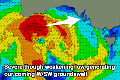
The last couple of days a severe low projecting towards WA has generated a fetch of severe-gale to storm-force W/SW winds on top an active sea state and ideally through our western swell window. This low is now weakening while pushing through the Bight towards us, and will push through the region this evening.
At the base of this system, an embedded low has formed today, with an additional fetch of strong to gale-force W/SW winds due to project more favourably through the South Coast's swell window, helping to provide plenty of size as the acute W'ly groundswell becomes shadowed by Kangaroo Island.
There's been no change to the expected size with the Mid Coast due to reach an easy 3-4ft into the afternoon tomorrow, easing from 3-4ft Friday morning, with Middleton building from 3ft+ or so tomorrow morning to 4-5ft later in the day, easing from a similar size Friday morning.
Winds will unfortunately remain onshore and out of the W/SW across the Mid Coast tomorrow, mostly fresh in strength but strong at times, with more favourable W/NW tending W-W/SW winds on the South Coast.
Friday looks best down South again with strong W/NW winds, swinging SW and then S/SW with a change midday/early afternoon.
Saturday is still looking the pick for the Mid Coast as winds shift S/SE in the wake of Friday's change along with fun smaller 2ft sets, holding most of the day. The South Coast looks to ease from 3ft+ but with those onshore winds.
We should see conditions improve again for the South Coast on Sunday along with some weak mid-period S/SW swell from weak fronts pushing up towards Victoria through Friday and Saturday.
Surf to 2-3ft is due across Middleton, not much bigger at the more exposed beaches and a morning W/NW breeze will favour protected spots.
Into next week some new inconsistent SW groundswell is due to fill in late Sunday but more so Monday and persist Tuesday, produced by a broad stretch of frontal activity through the south-east Indian Ocean over the coming days.
It'll be slow but Middleton should see 2-3ft sets, only tiny on the Mid Coast and to 1ft+ on the Mid with variable and local offshore morning winds.
There may be an additional S/SW groundswell in the mix Tuesday from a low forming south of WA on the weekend, but we'll review this and likely northerly winds in the next update.

