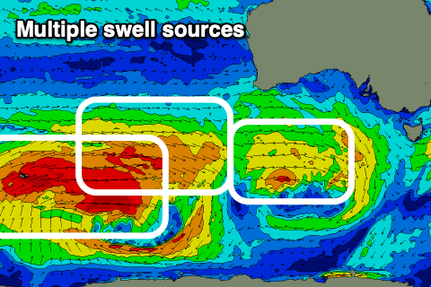
The good run of swell and conditions continue
South Australian Forecast by Craig Brokensha (issued Wednesday 22nd April)
Best Days: Tomorrow (early Mid Coast), later Friday Mid Coast, Saturday, Sunday morning South Coast, Monday, Tuesday
Recap
Our first solid pulse of W/SW groundswell for yesterday came in at a good 3ft on the Mid Coast, best early before winds freshened from the NW, great down South though windy and bumpy/choppy into the afternoon.
Today we've still got plenty of swell on the coast with cleaner conditions on the Mid and 2-3ft sets, 3ft+ off Middleton Point with more size down towards Day St with excellent conditions.


This week and weekend (Apr 23 - 26)
We'll see our current W/SW swell easing in size through tomorrow, but a reinforcing and slightly smaller W/SW-SW swell due this afternoon with slow this drop in size across both coasts.
It was generated by a strengthening mid-latitude front come low moving in from the west and now pushing east under Tassie. We'll see the Mid Coast dropping back to mostly 2ft tomorrow, with the possibility for the rare 3ft'er on the swell magnets early, while the South Coast should ease from 3-4ft across the Middleton stretch.
Winds will be favourable for both coasts again early tomorrow with a moderate to fresh N/NE-NE breeze on the Mid, shifting N/NW into the afternoon and NW later, with the South Coast being excellent all day with N/NE tending NW winds.
A temporary low point in swell is due Friday morning with a W/NW breeze on the South Coast, shifting onshore as a new inconsistent W/SW groundswell starts to fill in.
This swell has been generated in our far swell window, north-east of the Heard Island region as a strong mid-latitude front projecting up and towards WA. This system is currently weakening directly south-west of WA and will continue to to so this evening.
The swell should build through Friday afternoon and peak Saturday morning with sets to 2ft due later on the Mid, with the South Coast building from 2ft in the morning to 3ft later, while Saturday should see 2ft to occasionally 3ft sets across the Mid Coast, 3ft to possibly 4ft off Middleton.
Conditions will be favourable for both coasts again with a N/NE offshore down South, E/NE-NE early on the Mid, N/NW into the afternoon.
Moving into Sunday a trough will move through bringing a W to SW change along with some new SW groundswell, generated by a broad and strengthening fetch of W'ly gales south of the country tomorrow and more so Friday.
This should keep the Mid Coast around 1-2ft on Sunday, with Middleton coming in around 3ft+, though the conditions will be average apart from dawn.
Our stronger SW groundswell for Monday is on track, with a strong polar frontal progression developing around the Heard Island region yesterday evening, producing various fetches of severe-gale W-W/SW winds through our medium range swell window today and tomorrow. An additional weaker front spawning off the back of this low will project slowly towards us through the weekend, generating some additional but smaller mid-period energy.
The groundswell is due to head up and into us through the weekend, likely showing Sunday late but peaking Monday to 3-5ft across Middleton and 2ft+ across the Mid Coast on the favourable parts of the tide.
Conditions will be best down South with a morning W/NW breeze, possibly variable on the Mid and then locally offshore Tuesday morning as the swell eases, before increasing out of the north during the day with another approaching front.
Following this there's plenty more swell on the way though conditions don't look as favourable. More on this Friday.


Comments
How good is autumn!
Decent sized sets!
As an ex South Oz surfer (now in Vicco!)....can't help but over froth on a classic late arvo mid session. The reliable kick in size towards dark....the SSW winds starting to turn SSE, and then the sunset!
Had a good time working from home/watching the cams of Adelaide's 'D-Bah':
https://imgur.com/ktdWuEl
https://imgur.com/ZYRMbeP
Yep, was very jealous watching the cams through the day and evening today.
As you described, that arvo pulse, swinging of winds as the sun sets and driving home in the dark back up to my parents house in the north-east, sore and stoked. All while living the uni life. Great times.
You should’ve just driven to Winki which would’ve made you forget about the mid pretty quickly
Hah yeah true.
It's a childhood/growing up surfing memory though. I used to froth more on surfing glassy 3ft+ Seaford Bowl (those once a year swells!) than I do now surfing 6ft+ winki. Of course I can't imagine going back haha!
there was a place I called 'Perth's D-Bah' :) nice reference
it has been looking like suburb fun.