Easing surf ahead of new westerly and southerly swells
South Australian Forecast by Craig Brokensha (issued Monday 13th April)
Best Days: Tomorrow and Wednesday down South, Mid Coast Friday keen surfers, South Coast Friday morning, both coasts Saturday, Sunday down South
Recap
Poor conditions across both coasts on Saturday with onshore winds and building swells down South, 1-2ft and choppy on the Mid Coast.
Yesterday provided more size with a peak in S/SW groundswell and lumpy workable 4-5ft sets off Middleton and around Victor, clean and 1-2ft on the Mid Coast.
Today the swell has eased back with clean tiny 1-1.5ft sets on the Mid Coast, great down South with straight and clean 3ft+ sets along the Middleton stretch.
This week and weekend (Apr 14 - 19)
The coming days will continue to offer great waves across the South Coast with a new reinforcing S/SW swell due to arrive late today and offer good sized waves tomorrow morning, easing into the afternoon and further Wednesday.
This swell was generated by a good polar frontal system in our southern swell window over the weekend, in the wake of the strong front/low combo linked to yesterday's and today's swell.
The Middleton stretch should continue to see 3ft+ sets, easing slightly later and then back from a smaller 2ft+ Wednesday morning.
The Mid Coast will become tiny owing to the southerly direction of the swell.
Winds look great tomorrow morning, light to moderate N'ly ahead of weak E/SE-SE sea breezes, N/NE tending fresher N/NW winds Wednesday.
Overnight Wednesday a W'ly change will move through, linked to a strong mid-latitude front moving in under WA and then dipping south-east towards Victoria.
This and a stronger follow up low more to the south will move in later week, bringing another dose of large windy swell.
 I mentioned last Friday that there was plenty of Southern Ocean frontal activity on the cards for us this week, but it will stay at arms length distance.. well alas it now looks to move in and across us late week.
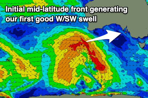
The first mid-latitude front will generate a great fetch of strong to gale-force W/SW, projecting ideally through the Mid Coast's western swell window, producing a moderate sized W/SW swell for Friday.
The swell is likely to build Thursday afternoon but with SW winds, with Friday seeing easy 3ft sets fill in through the day across the Mid Coast, with the South Coast seeing 4ft waves off Middleton. Winds will remain moderate to fresh SW on the Mid Coast and likely tend W/NW for a period during the morning down South, shifting SW mid-late morning.
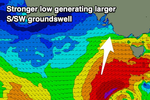
We'll see a moderate to large and reinforcing S/SW groundswell fill in Saturday, produced by a low forming south-west of Tassie behind the mid-latitude front, directing a fetch of gale to severe-gale SW winds in our southern swell window.
 This should peak Saturday afternoon across the South Coast with sets to 4-6ft, while the Mid Coast should continue to see 2ft+ sets all day as the W/SW swell slowly eases.
Conditions are looking more favourable with local light and variable winds, with great waves Sunday as the S/SW swell eases under N'ly offshores. We'll have a closer look at this in the coming updates though.

