Fun waves for exposed spots from mid-week
South Australian Forecast by Craig Brokensha (issued Monday 9th March)
Best Days: Wednesday until early afternoon exposed beaches, Thursday exposed beaches, Friday morning protected spots, Sunday morning
Recap
No waves on the Mid Coast and average surf down South, cleanest yesterday morning with E/NE winds for desperate surfers, bumpier on Saturday.
Today the surf was even smaller and weaker, with no real quality down South.
This week and weekend (Mar 10 - 15)
Tomorrow will be another lay day, but we've got a couple of fun days lining up for the exposed beaches from mid-week, and one morning to finish off the week.
The tiny swell seen today will drop further tomorrow and a morning E/NE-NE breeze will create generally clean conditions ahead of sea breezes.
Wednesday and Thursday are looking much better with a mix of new SW and S/SW swells along with favourable offshore winds.
 The first pulse of swells will consist of an inconsistent, long-range SW number and more consistent mid-period S/SW swell on Wednesday, generated by a distant polar low that formed around the Heard Island region late last week.
The groundswell has filled in across Western Australia today and should arrive late tomorrow on the coast but with sea breezes, peaking Wednesday. Also in the mix will be some more consistent mid-period energy from the secondary stages of the low in a much weaker form, pushing east along the polar shelf.
We should see inconsistent 2ft sets across Middleton, tiny on the Mid Coast with the swell direction not ideal, along with the lack of size. Winds will be great for the more exposed beaches which will be bigger, offshore from the N/NE, tending variable early afternoon ahead of sea breezes.
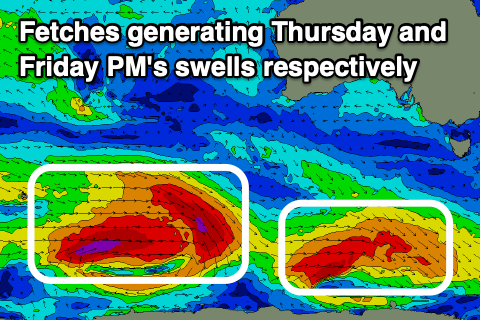
Our secondary pulse of better S/SW groundswell for Thursday morning is still on track, with a polar front that's currently south-southwest of WA generating a good pre-frontal fetch of strong W/NW-NW winds, followed by a post-frontal fetch of W/SW gales just within our southern swell window.
We'll see this provide a touch more size down South, more to 2ft to nearly 3ft off Middleton, bigger on the magnets. Conditions look great all day, with the swell easing into the afternoon under a fresh N/NE tending N/NW and then variable breeze.
Moving into Friday we'll see a dawn W/NW-NW breeze, shifting W/SW through the late morning ahead of a stronger SW tending S breeze into the afternoon.
A new long-period SW groundswell should be in the water from early morning, produced by a secondary, stronger polar frontal progression forming just east of Heard Island this morning, with a fetch of pre-frontal gale to severe-gale W/NW winds followed by post-frontal severe-gale W/SW winds, weakening south of WA tomorrow evening.
The swell will build Friday and should reach 3-4ft off Middleton through the middle of the day, with the early morning likely being more around 3ft. The Mid Coast will unfortunately miss out any decent size again owing to where the swell's being generated, coming in at 0.5ft max.
Into the weekend, a strong high will move in in the wake of Friday's change, bringing onshore SE-S/SE winds Saturday, around to the E/NE on Sunday but with a mix of easing S/SW swell and S/SE windswell to 3ft+.
Longer term we should see cleaner conditions develop next week with smaller, easing levels of S/SW swell but nothing of significance to follow. More on this Wednesday though.

