Strong swells out of the south as winds slowly improve
South Australian Forecast by Craig Brokensha (issued Wednesday 26th February)
Best Days: Friday experienced surfers down South, Saturday down South, Sunday morning down South
Recap
Tiny waves across the Mid Coast yesterday with a slight kick in onshore windswell today. The South Coast was average with onshore winds yesterday, cleaner this morning in protected spots, but winds have since shifted onshore and with strength.
This week and weekend (Feb 27 – Mar 1)
We've got tons of swell on the way out of the south-west and south, but for the most part winds will spoil the South Coast and the the swell won't really get into the Mid.
There are a couple of windows, so read on for more.
This afternoon we should see a mix of building SW groundswell and S/SW windswell from a broad and initial frontal progression moving through our swell window the last couple of days.
Any size seen later today will ease through tomorrow, back from 3-4ft across Middleton tomorrow and 1ft on the Mid Coast.
Winds look less than ideal and out of the SW across the South Coast tomorrow, with the chance of an early W'ly around Victor, while fresher breezes into the afternoon will create more bumps. Try protected spots for a grovel through the day. The Mid should be clean early with a light S/SE breeze, but tiny swell as mentioned above.
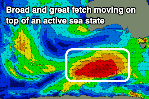
 Moving into Friday and our large S/SW groundswell is still on track, with a strong and tight polar low that formed south-east of the Heard Island region yesterday, now tracking east while generating a fetch of severe-gale W/SW winds along the polar shelf.
We'll see this low project north-east towards Tassie today and tomorrow morning while broadening in scope and moving on top of the active sea state generated by the fronts before it, producing a large, consistent S/SW groundswell.
The groundswell will be on the build from dawn but should peak through the middle of the day/afternoon with Middleton building to 6ft+, bigger at more exposed breaks and deep water reefs, but tiny on the Mid Coast and to 1ft.
Winds will unfortunately be onshore and out of the S/SW, but only moderate in strength so there should be some decent waves on offer all day for the experienced.
Saturday morning should offer cleaner conditions with some slight lump and wobble under a morning E/NE breeze, along with easing 4-5ft sets across Middleton, tiny on the Mid Coast. Get in before lunch and afternoon sea breezes.
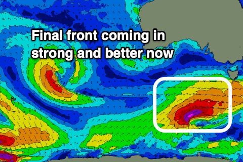
We're now expected to see a good reinforcing pulse of S/SW groundswell on Sunday as a trailing front fires up on the back of the system moving through over the coming days.
 A fetch of severe-gale to storm-force W/SW winds will be generated late in our swell window, but not too late not to make an impact.
A strong pulse of S/SW groundswell is due, building Sunday afternoon and kicking back to 4-5ft across Middleton from 3ft+ or so in the morning. Winds will be better in the morning and E/NE-NE, giving into stronger afternoon S/SE sea breezes, and unfortunately Monday as the swell eases but is still solid, we'll be seeing fresh to strong SE tending S/SE winds.
Longer term more polar activity looks to generate some decent S/SW groundswell mid-late week with more favourable winds. More on this Friday though.

