Time to lower the expectations for the coming fortnight
South Australian Forecast by Craig Brokensha (issued Monday 3rd February)
Best Days: Mid Coast on a fun board tomorrow, South Coast Friday morning
Recap
Poor surf across both coasts on Saturday, tiny and onshore Saturday while Sunday offered cleaner conditions in protected spots down South through the morning but a small and weak windswell. The Mid Coast kicked up to a choppy 1-1.5ft.
Today a mix of new W/SW and SW swells have provided more size across both coasts, 1-2ft on the Mid (a touch bigger than the expected 1-1.5ft) with improving conditions (below), choppy and to 2-3ft on the South Coast.

This week and weekend (Feb 4 - 7)
Today's mix of W/SW and SW swells are peaking and we'll see them dropping in size from tomorrow, further Wednesday.
Conditions will remain generally average down South but improve for a couple of breaks with a morning E'ly breeze, moderate to fresh in strength and with easing sets from 3ft off Middleton, clean on the Mid but 1-1.5ft.
 Wednesday will be smaller and with less favourable E/SE-E winds through the morning down South, clean but micro on the Mid Coast.
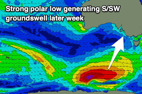
Looking into Thursday, and a strong new S/SW groundswell is still on the cards, with Friday morning looking the cleanest as it eases.
The S/SW groundswell has been upgraded in size and power, with the polar low linked to it now generating winds in the gale to severe-gale range while pushing east and then east-northeast under Tassie while weakening over the coming days.
This will be ideally through our southern swell window, with the long-period energy due to arrive early Thursday and peak through the day to a strong 3-5ft off Middleton, while the Mid Coast will be tiny to flat owing to the southerly swell direction.
Winds look unfavourable and out of the SE Thursday morning, increasing from the S/SE into the afternoon, while a more variable S/SE breeze is expected Friday morning as the swell eases back from 3ft or so off Middleton. It won't be perfect but fairly lined up and fun.
The swell will ease into the weekend and lingering S/SE winds look to create poor conditions on Saturday, better and out of the E/NE on Sunday but small and weak with 2ft or so of S/SE windswell.
Unfortunately the longer term outlook remains poor with a deepening surface trough moving slowly down the East Coast due to squeeze a strong high to our south, putting a block on our main swell windows and directing poor S/SE winds into the South Coast. A double whammy of summer slop. More on this Wednesday though.

