Lots of swell on the cards with lighter, workable winds
South Australian Forecast by Craig Brokensha (issued Friday 24th January)
Best Days: Both coasts tomorrow, Sunday morning South Coast, South Coast every morning next week, Mid Coast for bigger boards and beginners Monday and Tuesday
Recap
Developing stormy surf across the Mid Coast yesterday with fresh to strong onshore winds, better this morning with the swell dropping back to 2ft to occasionally 3ft with a lighter onshore breeze.
The South Coast was clean and great fun with a lift in new swell yesterday morning, even bigger and to 3-4ft through yesterday afternoon as winds shifted onshore. This morning is great with clean conditions and the swell hanging in between 3-4ft across the Middleton stretch.
Winds look to hold out of the west for most of the day, favouring protected locations as the swell steadies.
This weekend and next week (Jan 25 – 31)
We should see today's stronger SW groundswell peaking through this afternoon, easing off slowly through the weekend ahead of a new and strong kick in SW groundswell Sunday afternoon.
Winds and conditions are looking great for both coasts tomorrow with a light NW offshore down South, variable out of the N on the Mid Coast with easing sets from 3ft off Middleton, 2ft on the favourable parts of the tide across the Mid.
Sunday morning will be smaller and back to 2ft off Middleton, tiny though surfable on the right board across the Mid Coast. Winds look more variable Sunday morning out of the W down South, SE on the Mid ahead of sea breezes. The new SW groundswell due into the afternoon should see wave heights kick to 3ft to possibly 4ft by late in the day, 1-1.5ft on the Mid if we're lucky.
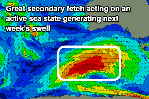
Sunday afternoon's groundswell is currently being generated by a strengthening and broadening polar low that's sitting south of WA.
 A slow moving fetch of W/SW gales will be projected through our south-western swell window today, broadening in scope tomorrow while weakening temporarily ahead of a secondary fetch of W/SW gales projecting on top the active sea state tomorrow evening and Sunday morning.
What should result is a moderate + sized and prolonged SW groundswell event from later Sunday through Tuesday, easing slowly and dropping in period and energy from Wednesday.
Later Sunday's pulse should hold Monday with 3-4ft sets off Middleton, 1-1.5ft on the favourable parts of the tide on the Mid, with a slightly stronger kick in size Tuesday with 4-5ft sets along the Middleton stretch but remaining around that teasing 1-1.5ft size. The swell should start easing from later Tuesday but more so Wednesday in both size and strength with the period dropping away.
Winds on Monday don't look great for the South Coast, but will only be light out of the S'th. With the strength of the swell there'll still be quality surfing options and nice lined up sets. The Mid should be clean ahead of sea breezes.
Winds are due to swing more E/NE on Tuesday morning, similar Wednesday, if not a touch more NE, with afternoon sea breezes each day. Conditions then look great for the exposed beaches as the swell eases into the end of the week with N/NE morning offhshores. Have a great weekend!


Comments
One long roller, way offshore.
