Good westerly swell for the weekend, plenty more action next week
South Australian Forecast by Craig Brokensha (issued Friday 10th January)
Best Days: Mid Coast on the weekend, South Coast Monday morning, Mid Coast later Tuesday and Wednesday
Recap
Much cleaner conditions yesterday down South with 2-3ft waves along the Middleton stretch, back to 1ft or so on the Mid Coast, pulsing a little with the incoming tide as winds tended variable.
This morning the surf was clean early down South ahead of a change, tiny and bumpy on the Mid Coast, with smokey weather from the Kangaroo Island fires.
This weekend and next week (Jan 11 – 17)
The good W/SW groundswell due to fill in tomorrow performed well across Western Australia and is now on the way east.
It should arrive later today but fill in properly through tomorrow with good 2ft waves on the Mid Coast (if not for the rare sneaky bigger one on the favourable parts of the tide). The swell will be on the ease into Sunday but holding 1-2ft, tiny Monday.
The South Coast should see a mix of groundswell, mid-period SW swell and S'ly windswell from today's front pushing through, coming in around 2-3ft off Middleton, easing from the 3ft range on Sunday morning. The additional pulse of S'ly groundswell from the deepening low late in our swell window Monday looks less likely, with it moving off to the east too quickly. Instead smaller, easing surf from 2ft+ is due off Middleton.
Looking at the local winds and the Mid Coast will be the pick tomorrow with a fresh S/SE breeze, more SE-E/SE into Sunday, with E/SE-E winds down South, not ideal.
 Monday is the pick down South and for the swell magnets with a N/NE offshore ahead of a S/SW change.
A weak trough moving through on Monday, bringing this change still looks to bring onshore S/SE winds with a low point in swell early Tuesday ahead of a strong new building W/SW groundswell into the afternoon.
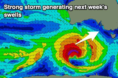
This swell has been upgraded since Wednesday, with the source being a tropical depression being absorbed into the westerly storm track from the southern Indian Ocean.
As it tracks south-east it will super-charge a frontal system moving in from the south-west, with a slow moving and strengthening fetch of W/SW gales due to move slowly through our western and then south-western swell windows on Sunday and Monday, finally dipping east-southeast under Tassie.
A moderate sized W/SW tending SW groundswell is due from these developments, kicking strongly Tuesday afternoon and peaking overnight/early Wednesday morning.
The swell should kick to 2ft on the sets across the Mid Coast with 4ft sets off Middleton, easing from 1-2ft and 4ft respectively Wednesday morning with what looks to be persistent S'ly winds. The models are divergent regarding this though, so check back here Monday for a clearer idea on this. In any case into the end of the week it looks like a strong high will bring strong S/SE winds and poor levels of S/SE windswell for the South Coast for an extended period, so make the most of the coming waves! Have a great weekend!


Comments
Early high tide not helping, but the Mid's looking fun.

It jacked again today on the incoming:)