Better waves opening up from Sunday

South Australian Forecast by Craig Brokensha (issued Friday 13th December)
Best Days: Sunday morning South Coast swell magnets, Monday morning South Coast, Tuesday morning South Coast swell magnets, Mid Coast Thursday
Recap
Poor surf continued across both regions yesterday while today there's a touch more swell on the South Coast with a little less onshore wind. All in all though it's still poor.
This weekend and next week (Dec 14 - 20)
Similar levels of swell to today are due on the weekend across the South Coast (tiny on the Mid) owing to weak fronts pushing through the edge of our swell window yesterday and today.
Our models are incorrectly combining long-range and small mid-period S/SW swells and overcooking the size, with small sets to 2ft along the Middleton stretch, more around 3ft on the sets at Waits and Parsons.
Winds will remain onshore and out of the SW tomorrow, with Sunday being the pick with a light morning N/NE offshore ahead of S/SE sea breezes.
Our new, long-period and inconsistent W/SW groundswell for later in the day and Monday is still on track, generated by a strong but distant low that formed north of the Heard Island region, followed by a fetch of W/NW gales moving east-southeast through our south-western swell window.
There'll be long waits for the sets but the swell should build to 2-3ft by dark Sunday off Middleton and peak to 3ft on Monday, with 0.5-1ft sets on the Mid Coast late Sunday and to 1ft on Monday.
Winds look favourable for both coasts Monday morning with local offshore winds (E/NE on the Mid and N down South) giving into afternoon sea breezes, good again Tuesday morning down South with a NE-N/NE offshore and small, easing swell from 2ft off Middleton.
 Wednesday morning looks clean again with a light N'ly offshore but the surf will be tiny, with some new small W/SW swell due into the end of the week.
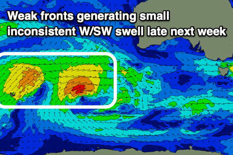
This will be generated by back to back mid-latitude fronts firing up to the west-southwest of WA this weekend. Mid-period W/SW swell energy is expected across our coasts late Wednesday but more so Thursday coming in at 1-2ft on the favourable parts of the tide on the Mid Coast and only 2ft+ across the South Coast.
Conditions look favourable and hot with morning offshore winds from the north-eastern quadrant ahead of sea breezes, and NE tending NW on Friday. Longer term we may see a broad and strong low deepening while dropping south-east late next week, generating a new swell for late in the weekend, but more on this Monday. Have a great weekend!