Plenty of good surf days to chose from

South Australian Forecast by Craig Brokensha (issued Monday 22nd July)
Best Days: Protected spots down South tomorrow, South Coast Wednesday and Thursday, Mid Coast early Thursday and Friday, both coasts Saturday, South Coast Sunday
Recap
Friday's kick in new swell held well into Saturday on the Mid Coast but conditions were average with a strong N'ly wind. The South Coast offered better though blowy conditions, with lighter winds yesterday.
Today the Mid Coast is building in size with but with poor conditions, small, clean and best on the magnets across the South Coast.
Today’s Forecaster Notes are brought to you by Rip Curl
This week and weekend (Jul 23 - 28)
We've got a good to great week of waves ahead for the South Coast with a large, long-period W/SW groundswell followed by plenty of reinforcing energy and genrally offshore winds until Friday.
Over the weekend, a significant frontal progression developed south-west of WA, with a pre-frontal fetch of severe-gale W/NW winds setting in motion an active sea state for a stronger storm-force fetch of W/SW winds to move over, in our western swell window.
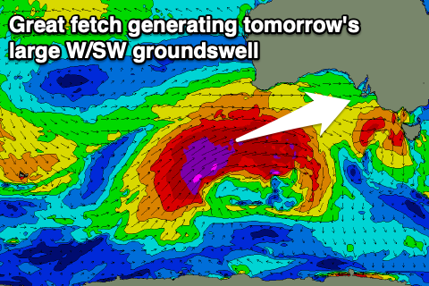 The frontal system is currently south of WA and continuing to aim a fetch of W/SW gales through our western swell window, with severe-gale W/SW winds in our south-western swell window (generating a reinforcing swell on the backside of the event Wednesday afternoon).
We should see the swell building strongly from tomorrow morning, reaching a large 5-6ft+ across the Middleton stretch into the afternoon and 4ft on the sets across the Mid Coast.
Winds will be a bit of an issue at times, fresh to strong from the W/NW most of the day, creating poor conditions on the Mid, cleanest in protected spots down South.
Wednesday looks good with a moderate W/NW offshore, swinging more NW into the afternoon and even N/NW on dark as another front approaches. Size wise, the Mid Coast looks to ease back from 3ft+, with 5-6ft sets off Middleton, a little smaller again Thursday with a moderate to fresh N/NW offshore. The Mid will likely see an early N/NE breeze and decent sets to 2ft, worth a surf.
Later in the day Thursday, a new W/SW groundswell is due to build ahead of a peak Friday. This will be generated by a good fetch of pre-frontal W/NW gales moving in and under WA over the coming days.
The Mid Coast should persist at 2ft on the sets, with 3ft to occasionally 4ft waves off Middleton and winds will swing around to the S/SE around dawn as a surface trough slips in from the west. This will see the attention swing from the South Coast to the Mid Coast with those fun sets.
Following this the surf is expected to ease slowly into Saturday ahead of a new reinforcing SW swell for Sunday morning. This will be generated by a weaker but good polar frontal system later week, keeping Middleton topped up around 3ft on the sets, 1-1.5ft on the Mid Coast. Winds look OK, variable early on Saturday before swinging to the W with an approaching front and then NW tending W/NW on the Sunday.
Longer term there's nothing too significant on the cards and winds will switch to the south early next week as a high moves in. More on this Wednesday.
Comments
Incoming!
Just a question with your forecast charts: there’s the three part graph with 6am, 12pm, 6pm readings for primary swell in metres, is that the size forecast to hit the nearest buoy at that time or impact the shore?
Yeah it's for a virtual buoy point, around 5km directly offshore of which way the coast faces. For the Mid Coast though it's more off the North Coast of Kangaroo Island.
To match with the CDC buoy, check the Kangaroo Island West Coast forecast.