Large, windy surf this week
South Australian Forecast by Craig Brokensha (issued Monday 27th May)
Best Days: Protected spots on the South Coast tomorrow morning, novelty spots Wednesday afternoon, Mid Coast Thursday morning
Recap
Good waves in protected spots most of the weekend down South, biggest yesterday, while the Mid Coast saw bumpy and small 1-2ft waves on Saturday, choppy and building surf to 2-3ft yesterday.
This morning all coasts are average with a larger onshore mix of swells to 4-6ft off the South Coast and choppy 2-3ft on the Mid Coast.
Today’s Forecaster Notes are brought to you by Rip Curl
This week and weekend (May 28 – Jun 2)
Today's windy and solid swell on the South Coast is a result of vigorous back to back cold fronts pushing into us, with the second system now clearing to the east as a secondary front approaches from our south-west.
Now, the dynamics around the vigorous polar frontal progression that's starting to shape to our south-west have changed a little.
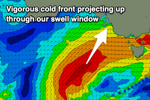
 Instead of a slow moving fetch of severe-gale to storm-force S/SW winds in our southern swell window, we're now expected to see a vigorous polar frontal system project north-east towards us, taking a turn more up and into us through tomorrow before pushing in and across the South East Wednesday morning.
The size has been downgraded a touch owing to the wind strength in this progression being gale to severe-gale and not storm-force, but the projection towards us tomorrow will still generate a large and powerful S/SW groundswell.
Tomorrow morning we'll be in between swell events with a drop in the localised SW swell today coming at 3-4ft off Middleton and 2ft+ on the Mid Coast, but the approaching front will bring an increase in W/SW windswell and mid-period swell through the afternoon, reaching 3ft on the Mid Coast, though likely not changing too much in size on the South Coast. Winds will strengthen from the W/NW-W, shifting W/SW later in the afternoon.
Come Wednesday we should see the large long-period S/SW groundswell filling in, building to 8ft+ across most locations on the South Coast into the afternoon and hanging around 3ft on the Mid Coast, but with strong W/SW tending SW-S/SW winds.
This will create poor conditions across most locations, while we'll unfortunately see persistent onshore S'ly winds Thursday, less strength Friday but still onshore. The Mid Coast will be cleaner Thursday with a morning S/SE breeze and easing 2ft sets, tiny into the afternoon.
A very slow moving blocking high will sit across our swell window into the end of the week and weekend, resulting in no new swell with persistent winds from the south-east. Later next week some new W/SW groundswell is on the cards, but distant and inconsistent. More on this Wednesday.

