Great days ahead for the South Coast

South Australian Forecast by Craig Brokensha (issued Friday 10th May)
Best Days: Protected spots South Coast tomorrow AM and Sunday, Monday and Tuesday both coasts, Wednesday South Coast, Thursday South Coast
Recap
Poor conditions across the South Coast yesterday and today, while the Mid Coast saw a mix of NW windswell yesterday morning and underlying W/SW swell, with slightly better conditions this morning with a S'ly wind and 2ft to occasionally 3ft sets.
Today’s Forecaster Notes are brought to you by Rip Curl
This week and weekend (May 11 – 17)
This afternoon's increase in W/SW windswell and SW groundswell will ease back through tomorrow and we're now expected to see a period of W/NW winds around Victor early morning.
 Easing surf from 3ft+ off Middleton is due tomorrow, clean before winds shift W/SW later morning. The Mid Coast looks to remain average and onshore with easing 1-2ft surf.
Sunday through Wednesday are shaping up to be excellent to pumping with a large S/SW groundswell due to fill in, followed by a reinforcing SW swell on Tuesday.
We've got one prolonged S/SW groundswell event now on the cards instead of two seperate S/SW groundswell pulses.
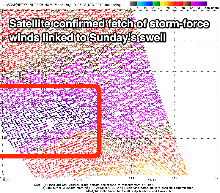
Currently a very intense and broad polar storm is generating an elongated fetch of severe-gales, with stronger embedded storm-force winds in our south-western swell window.
It'll continue east towards Tasmania while slowly weakening this evening as a secondary front fires up on its tail, producing an additional fetch of severe-gale W/SW winds on top the active sea state in our southern swell window.
A large and prolonged long-period S/SW groundswell event is due, with it arriving Sunday morning and building to a strong 6ft into the afternoon across Middleton, with 2ft sets on the Mid Coast.
Monday morning should offer similar sized surf with the prolonged nature of the swell to 5-6ft off Middleton and 2ft on the sets across the Mid Coast, easing through the day.
 Winds are still looking best for protected spots on Sunday down South with a persistent W/NW breeze, pumping Monday with a fresh N/NW'ly, tending W/NW through the mid-late afternoon. The Mid Coast should see an early N/NE breeze before swinging W/NW.
A reinforcing SW groundswell is due on Tuesday, produced by a strengthening and fast tracking low moving in under the country on Sunday and Monday. A fetch of W/SW gales will be projected through our south-western swell window, with the SW swell expected to maintain 4ft sets off Middleton and 1-2ft waves on the Mid Coast along with a NW offshore down South (N/NE on the Mid early again), swinging W/NW and then W/SW through the afternoon.
The swell will ease Wednesday with great offshore N'ly winds ahead of SE sea breezes.
Thursday looks clean again but with a low point in swell, best on the swell magnets, while into the afternoon and more so Friday, a new long-period S/SW groundswell is due to fill in. The source of this swell will be an intense but slightly weirdly structured polar low east of Heard Island early next week. At this stage it looks like we may see surf to 4-5ft off Middleton though a trough moving in during the day will bring a S/SE change after an early W/NW breeze. More on this Monday, have a great weekend!
Comments
“excellent to pumping”. Great frothing Craig!