Easing surf ahead of a large powerful groundswell late week

South Australian Forecast by Craig Brokensha (issued Monday 22nd April)
Best Days: Keen surfers South Coast tomorrow morning, protected spots Thursday South Coast, Friday afternoon Mid Coast, Saturday Mid Coast, Sunday South Coast
Recap
Tiny waves on the Mid Coast Saturday but kicking to 2ft with a new W/SW swell yesterday with workable onshore winds. The South Coast dropped back a little more than anticipated on Saturday but the magnets were great with all day offshores, while Sunday started small and clean, bigger but onshore into the afternoon.
Today our close-range SW swell has kept the Mid Coast up around 2ft with good clean conditions early this morning, a touch bumpy this afternoon while the South Coast was a bit bigger though not to the expected size and onshore.
Today’s Forecaster Notes are brought to you by Rip Curl
This week and weekend (Apr 23 - 28)
The close-range SW swell seen later yesterday and this morning is already on the ease, with the strong and intense low linked to it on Saturday dipping quickly out of our swell window.
With this we'll see the swell continuing to drop tomorrow, with fading tiny 1ft+ waves on the Mid Coast and 2ft off Middleton with morning offshore winds (E/SE Mid Coast and NE South Coast) ahead of afternoon sea breezes.
We're still looking at a low point in swell Wednesday morning, but a mix of very inconsistent and small long-period W/SW groundswell and closer-range mid-period SW swell are due to build through the afternoon.
The long-range swell was generated in our far far swell windows, south-east of South Africa, and won't have any major size attached to it. Middleton may build to 2ft late Wednesday and reach 2-3ft on Thursday, with 1ft+ sets on the Mid Coast.
The closer-range mid-period SW swell will be generated by a relatively weak mid-latitude front moving in south of WA, and dipping east-southeast while strengthening this evening and tomorrow.
The swell should come in around a similar size to the long-range groundswell but with more consistency Thursday. Coming back to the winds on Wednesday though and the Mid Coast will be clean ahead of sea breezes, with the South Coast peaky with a variable E'ly wind ahead of sea breezes.
 Thursday looks cleaner down South with a light W/NW breeze, freshening and swinging W'ly, while the Mid Coast will deteriorate after variable winds at dawn.
A secondary pulse of SW groundswell is due on Thursday afternoon, generated by a secondary mid-latitude front moving in under WA. This should produce a a good pulse of swell to 3ft+ later Thursday off Middleton and 1-1.5ft on the Mid Coast but with that strengthening W'ly wind.
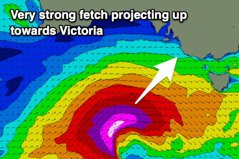
Of greater importance is the third in the series of these frontal systems, with it due to deepen significantly south of WA Wednesday evening, projecting a fetch of broadening severe-gale to storm-force W/SW winds south of the Bight and up towards Victoria.
A large, long-period SW groundswell will be generated, with it building rapidly Friday afternoon, at this stage reaching 8ft off the Middleton stretch and other deep water reefs, while the Mid Coast should kick to 2ft to 3ft with the push of the tide.
Winds will swing around to the S/SW and then S on Friday as a high moves in behind the severe low generating Friday's swell, with late S/SE winds on the Mid Coast, creating good improving conditions.
Another weaker front clipping the state will keep onshore S/SW winds on the Coast Saturday as the large SW groundswell eases, while the Mid should see a morning S/SE'ly.
Sunday looks cleaner down South with a morning W/NW breeze and plenty of size, though easing. We'll have a closer look at this swell and beyond on Wednesday.