Fun W'ly swell Sunday, strong new swells from mid-next week

South Australian Forecast by Craig Brokensha (issued Friday 12th April)
Best Days: Mid Coast and South Coast Sunday, South Coast later Wednesday, keen surfers both coasts Thursday, both coasts Friday
Recap
Good improving surf all morning yesterday on the South Coast with lumpy and good sized sets persisting off Middleton, tiny and to 0.5-1ft on the Mid Coast.
This morning the swell was smaller but cleaner and best at Waits and Parsons down South, with a tiny northerly windswell on the Mid Coast.
Today’s Forecaster Notes are brought to you by Rip Curl
This weekend and next week (Apr 13 - 19)
If you're desperate for a wave tomorrow you'll probably find one on the South Coast swell magnets to 2ft or so, but keep your expectations low. It'll just be an inconsistent background swell.
Winds will be favourable and offshore from the NE, tending E/SE-SE into the mid-late afternoon. The Mid Coast will be clean though flat, with a possible late increase in W'ly groundswell that's due Sunday.
 Sunday's swell is looking good, with it rising rapidly across Western Australia this morning and coming in large across Margaret River. This swell will favour the Mid Coast over the South Coast with good though inconsistent 1-2ft sets due, though the tidal movement is minimal and not too favourable. Middleton should see inconsistent 2ft sets and E/NE-NE winds should create decent conditions most of if not all of the day.
The swell will ease through Monday from a tiny 1ft+ on the Mid Coast and 1-2ft off Middleton as winds swing straighter offshore from the N/NE, N/NW into the afternoon.
A small and inconsistent background may keep 1-2ft waves hitting the South Coast Tuesday morning with an offshore wind and afternoon sea breezes.
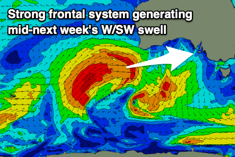
Of greater importance are the W/SW swells due from Wednesday through the end of the week generated by strong polar fronts being steered up and across Western Australia by a pronounced node of the Long Wave Trough.
The first storm will form around Heard Island and project a great fetch of severe-gale W/SW-SW winds north-east up towards WA, through our western swell window. The front will then push under the WA coast and weaken, generating a moderate to large sized W/SW groundswell.
The swell should kick strongly Wednesday afternoon and peak early Thursday. The Mid Coast should build to 2-3ft Wednesday afternoon, with 3ft sets persisting Thursday though with strengthening N/NW winds on the former and moderate to fresh W/SW tending SW winds on the later in the wake of a front.
The South Coast should see great waves into the late afternoon and evening Wednesday with the swell building towards 3ft off Middleton under that N/NW winds. Thursday looks to be more around 3-4ft with with dicey winds.
Longer term we're likely to see a reinforcing W/SW and SW swell for Friday generated by a another front moving up towards WA, combined with a polar fetch of W/SW gales. Winds look better with a return to N/NE breezes with an approaching front (producing another W/SW swell for the Easter Weekend, but more on this Monday. Have a great weekend!
Comments
Glorious afternoon for the loggers down south.

Nostalgia hey Ben?
Indeed. Can't believe what I used to froth on.