Fun easing surf with a small W'ly swell for the weekend

South Australian Forecast by Craig Brokensha (issued Wednesday 10th April)
Best Days: South Coast tomorrow morning and South Coast magnets Friday morning, Mid Coast Sunday and keen surfers down South
Recap
Poor conditions and large surf on the South Coast yesterday, better on the Mid Coast with good surf pulsing to 3ft working the tides and generally OK winds, improving later afternoon and great for the late.
Today both coasts were much cleaner with inconsistent but good 2ft sets on the Mid Coast, and glassy/lumpy 3-5ft surf on the South Coast.
Today’s Forecaster Notes are brought to you by Rip Curl
This week and weekend (Apr 11 - 14)
The coming days are looking really fun on the South Coast as the current swell continues to ease while tending more S/SW in direction. This will see the Mid Coast become tiny tomorrow but the South Coast super fun with offshore winds.
A morning N/NE breeze will create great conditions tomorrow with easing 3ft+ sets off Middleton, though the afternoon will become bumpy as winds swing more E-E/SE.
Friday will be best at swell magnets with a straight N'ly tending NW breeze and small fading 1-2ft sets off Middleton, 2ft to possibly 3ft at Waits early, smaller through the day.
 The weekend is a bit hit and miss with a small background SW groundswell not likely to offer much over 1-2ft off Middleton Saturday, with tiny waves on the Mid under a morning E/NE breeze.
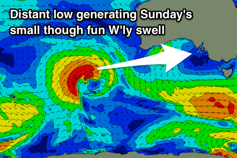
Our small and acute W'ly swell for Sunday is still on track, with a strong but distant low sitting fairly north in latitude currently projecting a fetch of strong to gale-force W/SW winds towards WA.
This is in the Mid Coast's swell window, but not too ideal for the South Coast, with a possible late increase in size due Saturday ahead of a peak Sunday to an inconsistent 1-2ft on the Mid Coast. Middleton looks to only be an infrequent 2ft as winds persist out of the E/NE.
Monday will become cleaner down South with a N/NE offshore but the swell will be small and fading from an inconsistent 1-1.5ft off Middleton and 1ft on the Mid Coast.
As touched on last update, a strong node of the Long Wave Trough will develop across Western Australia, directing a series of strong polar fronts up and into them, through our western swell window.
We'll see good W/SW groundswells generated for us from mid-next week and with what looks to be favourable winds for the Mid Coast as the fronts dip south-east and away from us. The first swell looks to build through Wednesday, but more on this in Friday's update.
Comments
Trigs looking unreal!

Even Cliffs showing nice peaks.

Conditions for the Robe Easter Classic are looking good,especially if the wind goes easterly!!