Good surf days for both regions over the coming week

South Australian Forecast by Craig Brokensha (issued Monday 8th April)
Best Days: Mid Coast tomorrow and South Coast into the afternoon, both coasts Wednesday, South Coast Thursday, Mid Coast Sunday
Recap
An average start to the weekend across both coasts but a new W/SW swell filling in through the afternoon Saturday with relatively light winds provided good options on the Mid.
Sunday was cleaner and better across all locations with the swell hanging in at 1-2ft on the Mid Coast, with clean 2-3ft waves off Middleton and good options at Waits and Parsons.
Today a stronger groundswell is currently building across the coast with great conditions in protected spots on the South Coast, building from 3-4ft this morning. The Mid Coast is a bit of mess but building in size with Cape du Couedic hitting Significant Wave Heights of 5m at 16s.
Today’s Forecaster Notes are brought to you by Rip Curl
This week and weekend (Apr 9 - 14)
The first of two large long-period groundswells is on the build today, generated by a polar low that formed around Heard Island mid-last week and then moved slowly east and then up towards us through the weekend while generating a fetch of severe-gale W/SW winds.
A large long-period W/SW-SW groundswell should reach 6ft off Middleton later today and 2-3ft on the Mid Coast as winds swing more W'ly and then W/SW later.
 This swell will be reinforced by a secondary large long-period SW groundswell tomorrow, produced by a secondary front pushing up on top of the active sea state generated by the first storm.
The fetch didn't quite reach the storm-force range as forecast and as a result there's been a slight downgrade in the expected size. Middleton should peak around 6-8ft, with 2-3ft sets on the Mid Coast and winds are still looking best for the later.
A high moving in behind a change overnight will leave moderate to fresh S/SW winds across the South Coast, easing through the day creating improving conditions. The Mid should see a favourable morning S/SE breeze, S/SW into the afternoon.
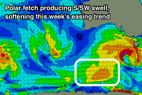
The easing trend will be slowed by a good fetch of trailing SW winds drawn out from the polar shelf, up to us through this evening and tomorrow, with a slight intensification from a weak polar front.
Winds are expected to swing back to the E/NE-NE on the South Coast Wednesday morning cleaning up conditions with easing 4-6ft sets off Middleton before S/SE sea breezes kick in, while the Mid Coast will be clean and easing from 2ft.
As the swell swings more S/SW in direction Thursday the Mid Coast will become tiny, but the South Coast great with easing 3ft to likely 4ft sets and an offshore N/NE breeze, holding until early-mid afternoon ahead of late sea breezes.
Friday will be clean again but you'll need to head to the swell magnets with 1-2ft leftover sets at Middleton with a N tending NW breeze.
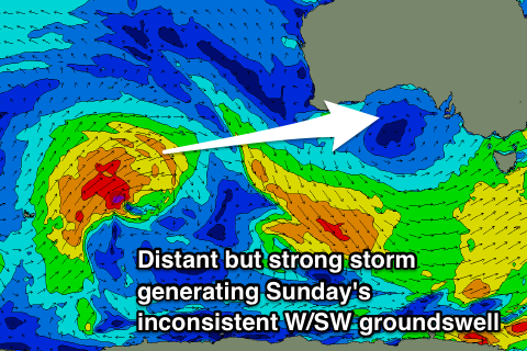 The weekend will be mixed and best Sunday. A surface trough moving through Saturday will bring poor S/SE winds with small to tiny swells, but a new inconsistent W/SW groundswell is due to arrive overnight Saturday and peak Sunday.
The storm linked to this swell is forming north-west of the Heard Island region and will project east-northeast towards WA while generating a fetch of strong to gale-force W/SW winds through our western swell window. The low will weaken while dipping east-southeast under WA, leaving a fun though inconsistent W/SW swell for Sunday. The Mid Coast should be a fun though inconsistent 2ft on the sets, with 2ft waves off Middleton under an E/NE breeze.
Longer term a much more significant front and low pushing up towards WA looks to generating a long-period W/SW groundswell for mid-late week, but we'll review this Wednesday.