Mostly clean all week down South, large swell into next week

South Australian Forecast by Craig Brokensha (issued Monday 1st April)
Best Days: South Coast tomorrow, Thursday later morning South Coast, Mid Coast Saturday afternoon, South Coast Sunday morning
Recap
Plenty of swell over the weekend with sloppy average conditions down South Saturday, better on the Mid Coast with workable onshore winds. Sunday remain average with a persistent onshore breeze down South and variable winds on the Mid Coast.
Today a new S/SW groundswell has filled in keeping the surf up around 3-4ft on the South Coast with light winds and improving conditions and clean tiny 1-1.5ft waves on the Mid Coast.
Today’s Forecaster Notes are brought to you by Rip Curl
This week and weekend (Apr 2 - 7)
Today's new groundswell has peaked and we should see it easing off slowly into tomorrow, further Wednesday and with great winds. Tomorrow is the pick with a great offshore N/NE wind that looks to hold until early afternoon, tending variable in some locations and likely SE later afternoon.
Middleton is expected to ease back from a good 3ft, while the Mid Coast will be tiny.
A N/NE tending W/NW breeze should be seen on Wednesday (SW late in the day), best through the morning on the magnets with small fading 1-2ft sets off Middleton.
A weak front moving in south of the Bight over the coming days should produce a small lift in swell for Thursday as winds swing back to the N/NE through the morning and even straighter N'ly early afternoon ahead of sea breezes.
With winds struggling to reach gale-force the swell will be on the weaker side but should provide 2ft+ waves off Middleton, best at Waits and Parsons. The Mid Coast won't be flat but will struggle to top 1ft from this swell source.
 Friday will be clean again on the South Coast but the swell small and fading from 1-2ft off Middleton.
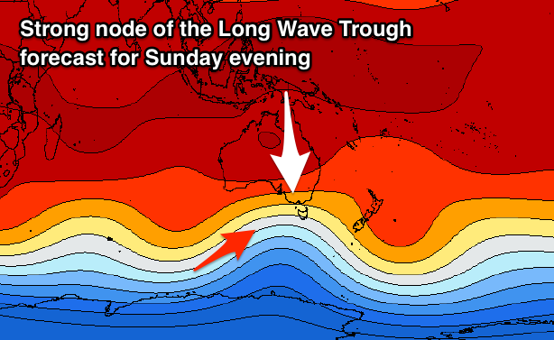
Of greater importance are the developments for early next week, with a strong node of the Long Wave Trough forecast to develop across WA later this week and then push east through the weekend and early next week.
We can expect a significant Southern Ocean frontal progression, forming Friday south-west of WA and then broadening in scope and nearing closer through the weekend.
 Saturday will start tiny with a good spike in acute W/SW through the afternoon, generated by an initial right mid-latitude low forming under WA. The Mid Coast will offer the most size with a kick to 2-3ft due by dark but with a workable and only moderate onshore W/SW breeze. The South Coast will see fun waves Sunday with 2-3ft sets along the Surfers stretch under a morning W/NW breeze.
More exciting though is a very significant and large SW groundswell for early next week produced by an elongated and broad fetch of severe-gale to storm-force W/SW-SW winds through our south-western swell window.
The swell is due to build later Monday and peak Tuesday to 6-8ft off Middleton with SW winds, but we'll have a closer look at this on Wednesday.
Comments
Knights looking like a lil' point!
