Generally average weekend, on the improve early next week

South Australian Forecast by Craig Brokensha (issued Friday 29th March)
Best Days: Possibly Mid Coast tomorrow morning, South Coast keen surfers later morning Monday, Tuesday South Coast
Recap
Great waves across the South Coast yesterday before winds shifted more west into the afternoon, while early this morning was small and clean ahead of an onshore change.
The Mid Coast was a tiny 0.5-1ft yesterday, even smaller this morning but a stormy windswell is now whipping up across the gulf.
Today’s Forecaster Notes are brought to you by Rip Curl
This weekend and next week (Mar 30 – Apr 5)
It seems Ben's been keeping the Southern Ocean more than active over the past couple of weeks in my absence, but coming in a little cold to the forecast period, especially this weekend is somewhat tricky. A new long-period groundswell forecast for later today and tomorrow doesn't look to quite reach the expected size Ben had in the last update.
A quick look back at the polar storm linked to it reveals a good fetch of gale-force winds wrapping around a polar low and projecting nicely through our south-western swell window.
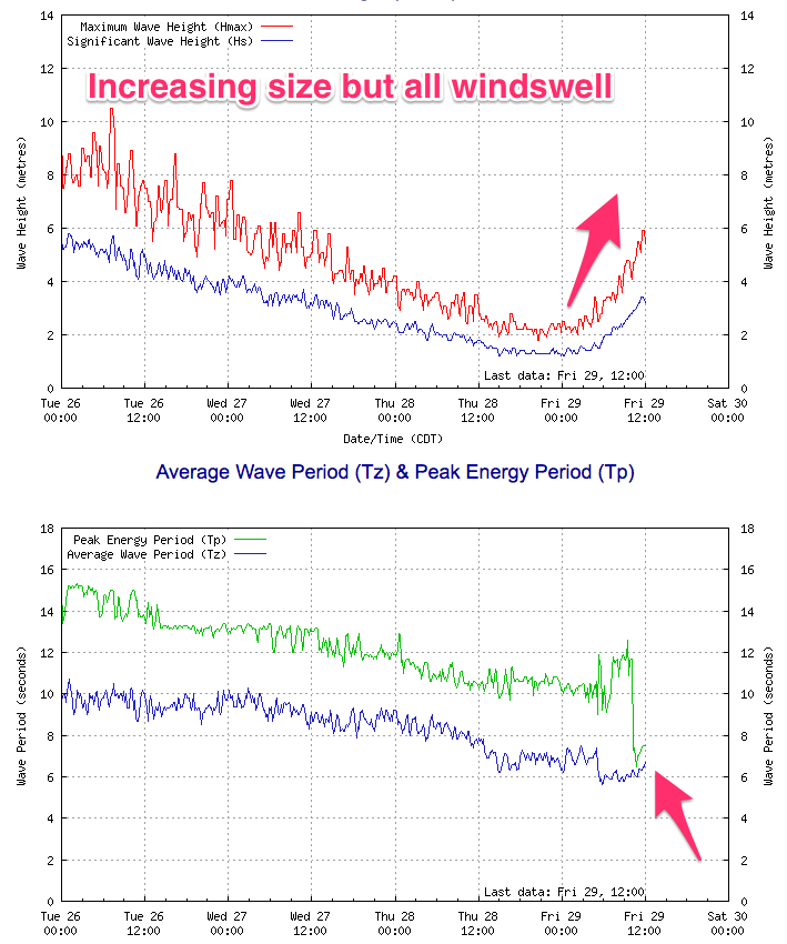
We should the swell building later today though the increase shown on the Cape du Couedic wave buoy is all just windswell, a dead give away is the low periods of 6-8s. This is from a strong front spawning off the polar low, whipping up 2-3ft of stormy windswell already on the Mid Coast.
The front will push past us through tomorrow, but winds will remain onshore and out of the SW across the South Coast as the SW groundswell peaks to 3-4ft. The Mid Coast may see a period of S-S/SE winds creating workable waves and with easing 2-3ft of windswell and groundswell.
The surf will ease a touch Sunday morning and winds will remain onshore and moderate to fresh out of the SW as a weak front clips the south of the state.
A new long-period SW tending S/SW groundswell may be seen later Sunday but more so Monday. During today a good fetch of strong to gale-force W/NW winds will develop well south of Western Australia, tending more W'ly through our south-western swell window, followed by a gale-force SW fetch positioned more in our southern swell window.
This swell will favour the South Coast over the Mid and come in at 3-4ft across Middleton, while small levels of mid-period W/SW swell to 1-1.5ft. Conditions should improve through the morning across the South Coast with a variable tending E/NE breeze, but it'll take a while for things to clean up.
Tuesday looks the pick as winds come straight out of the N'th, tending W/NW into the late afternoon along with good easing sets from 3ft off Middleton. The Mid Coast looks to be a little wind affected and tiny to 0.5-1ft.
A further drop in size will be seen Wednesday with clean conditions but only small options at Waits and Parsons.
Longer term a deepening low projecting up from the south-west looks to bring an onshore and stormy increase in S/SW swell later next week, but we'll have another look at this Monday. Have a great weekend!
Comments
Heading over to KI next week (1st - 8th). Options looking pretty good, & pretty varied....thoughts on size & direction of swell later next week?
On the southern exposed coasts it looks large and out of the S/SW, building Friday and windy, easing quickly out of the S'th on Saturday.
This all depends on the strength of the low moving through, but it's looking fairly significant.
Thanks mate. Looking nice & clean early in the week with a novelty wave later in the week then! Cheers