Average weekend, good swells next week but poor winds for the South Coast

South Australian Forecast by Craig Brokensha (issued Friday 15th February)
Best Days: South Coast keen surfers Sunday morning, Mid Coast tiny peelers Monday afternoon, more so Tuesday
Recap
Solid clean surf in protected spots yesterday morning across the South Coast, still fun into the afternoon even with a bit of an onshore breeze. The Mid Coast was 1-2ft and fun before sea breezes got into it and the size dropped.
This morning the South Coast was still fun with some slight peaky and wobble as winds tended more north-east and solid 3-4ft sets off Middleton. It's great now and straightened right up with an offshore n/NE wind so hit it!.The Mid Coast was clean but tiny.
Today’s Forecaster Notes are brought to you by Rip Curl
This week and weekend (Feb 16 - 22)
From here on in we'll be on a downwards trend in surf across the South Coast as all the strong frontal activity form this week cleared off a day or so ago.
The small lift in size shown through tomorrow afternoon is due to the models incorrectly combining a new small mid-period swell with the easing S/SW energy.
 Instead we should see Middleton easing back from 2ft to possibly 3ft, down from a smaller 2ft Sunday morning. The Mid Coast will be tiny to flat.
Winds are still looking average and out of the SE tomorrow morning, tending S/SE through the day, while Sunday looks better with a more variable breeze ahead of increasing onshore winds late morning.
Monday will be a lay day with a low point in swell and strengthening S/SE winds as a cold front clips the state and high moves in from the east.
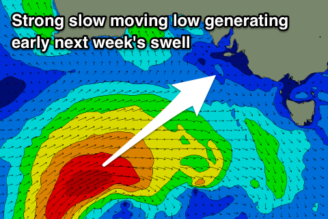
This front will be attached to a strong and slow moving low that's been upgraded in strength and intensity since Wednesday.
The low has formed south-west of WA but is quite small and weak, but we should see it stall, strengthen and then start projecting a slow moving fetch of gale to possibly severe-gale W/SW winds through our south-western swell window. The low will project under us Monday, bringing the onshore change.
The initial stages of the low may produce a tiny pulse of W/SW swell for the Mid on Monday to 1ft+ or so (into the afternoon), but the SW groundswell is due on Tuesday with 4-5ft sets off Middleton and better 1-2ft sets on the Mid.
Winds will be best on the Mid Coast as a S/SE-SE breeze persists, similar Wednesday as the swell eases.
Later in the week a new W/SW-SW groundswell is likely, with it forming in our far swell window over the weekend before the front generating it moves under the country next week. More on this Monday though. Have a great weekend!