Fun though not perfect end to the week, average from the weekend

South Australian Forecast by Craig Brokensha (issued Wednesday 13th February)
Best Days: Protected spots South Coast tomorrow morning, Mid Coast for tiny waves, beaches that enjoy an eastely wind Friday morning
Recap
Semi-stormy and average onshore 2-3ft waves on the Mid Coast yesterday with a large building choppy swell across the South Coast, maxing into the afternoon. This morning the swell was still large and messy down South, bumpy and to 2ft on the Mid Coast.
Today’s Forecaster Notes are brought to you by Rip Curl
This week and weekend (Feb 14 - 17)
We've passed the peak of the current swell event, with the strongest of the frontal systems moving through yesterday.
From here we'll be on a downwards trend towards the weekend, slowed by a good reinforcing mid-period S/SW swell later tomorrow and Friday morning.
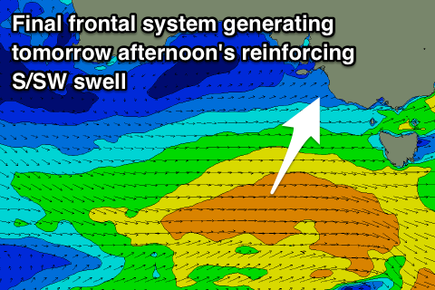 This will be generated today and this evening by a final strengthening front south of us, with a broad fetch of strong W/SW winds being aimed mostly towards Tasmania.
This swell will slow the easing trend, with Middleton due to still be solid and around 4ft tomorrow morning, easing from 3ft+ Friday morning and smaller to 2ft+ Saturday. The Mid Coast looks like it will be on the tiny side now and to 1-1.5ft, fading from 1ft Friday and tiny into the weekend.
Winds should be better across the South Coast tomorrow and out of the W/NW around Victor shifting light to moderate S/SW late morning, fresher into the afternoon. The Mid Coast should be clean also with a S/SE-SE offshore ahead of sea breezes.
Friday will then see winds swing to the E and likely tend E/NE for a period on the South Coast as a ridge of high pressure moves in from the west. Conditions won't be great but surfable in spots that like an easterly winds, average Saturday with a less favourable SE breeze. Unfortunately S/SE winds will persist Sunday with no new swell creating average conditions so make the most of the coming days waves.
As touched on last update, some new swell is due early next week from a slow moving low forming south-west of WA and pushing towards us through the weekend and early next week.
The winds associated with this swell look poor and onshore for the South Coast, better for the Mid initially though the direction isn't great and there'll be no decent size. More on this Friday.