Large building surf, cleanest as it slowly eases
South Australian Forecast by Craig Brokensha (issued Monday 11th February)
Best Days: South Coast dawn tomorrow, both coasts Thursday morning, South Coast Friday and Saturday mornings
Recap
Average building stormy surf through Saturday across the Mid Coast, easing back from a bumpy 1-1.5ft yesterday. The South Coast saw a good increase in size Saturday but with generally average to poor conditions, much better yesterday with a light W/NW offshore and good sized sets along the Middleton stretch.
Today conditions were excellent again down South with a slight drop in swell, choppy and to 1ft on the Mid Coast.
Today’s Forecaster Notes are brought to you by Rip Curl
This week and weekend (Feb 12 - 17)
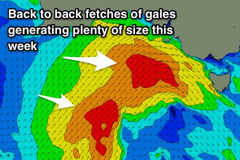
The current cooler weather and increase in swell activity is due to a strong node of the Long Wave Trough stalling across the south-east of the country. The node will start to weaken mid-week and slide off slowly to the east, but before this we'll see the strongest of the frontal systems through this period being projected up and towards us.
A good fetch of strong W/SW tending SW winds are being aimed up towards and through the Bight today, with the front pushing across us early tomorrow morning.
On the tail of the front a slightly weaker fetch of strong SW winds will be slung up towards and into the south-east corner of the state tomorrow afternoon, slowing the easing trend in size through the second half of the week while also keeping winds from the south-western quadrant.
 Size wise tomorrow we should see Middleton building from 3ft to maybe 4ft off Middleton early, up to 4-6ft later in the day, with a peak in size Wednesday morning to 5-6ft. The Mid Coast should build from a semi-stormy 2ft in the morning to an easy 3ft if not more through the day, easing back from 3ft on Wednesday.
Winds will be generally poor and strong from the W/SW tending weaker SW, with a dawn W/NW'ly likely around Victor, but it won't last long. Wednesday unfortunately will see SW winds across all locations. Thursday should hopefully be cleaner across both locations with a light W/NW breeze around Victor and light S'ly on the Mid with easing sets from 4ft and 2ft respectively.
A high will move in from the west late week resulting in winds swinging E/NE and we should still see plenty of size down South owing to one final frontal system forming in our southern swell window south of the Bight Wednesday.
This should keep Middleton around 3ft+, easing into the afternoon and down from 2ft to possibly 3ft Saturday morning. The Mid Coast will become tiny and to 1-1.5ft on the favourable parts of the tide Friday, even smaller Saturday. Winds Saturday look to hang from the E, more variable out of the W Sunday as the surf becomes small.
Longer term there's the possibility of a good SW swell early next week, but winds look to be gusty and persistent out of the S/SE as another strong high moves in from the west. More on this Wednesday.

