Poor surf until Sunday

South Australian Forecast by Craig Brokensha (issued Wednesday 6th February)
Best Days: South Coast Sunday morning, Monday morning, Tuesday morning
Recap
Solid junky waves out of the S/SE yesterday morning but with poor conditions, tiny on the Mid Coast though pulsing to an inconsistent 1ft+ at magnets through the afternoon.
This morning lighter onshore winds have created improving conditions across the South Coast with 2-3ft of S/SE and S/SW swell, while the Mid Coast has remained poor.
Today’s Forecaster Notes are brought to you by Rip Curl
This week and weekend (Feb 7 - 10)
I hope you made the most of this morning's cleaner conditions on the South Coast, as we're in for a run of poor winds and surf until Sunday.
The surf will become smaller and weaker tomorrow with a moderate onshore S'ly wind, similar Friday but with fresher S/SW winds. The Mid Coast won't offer anything of note either.
Saturday will again start poor with a weak S/SW swell and moderate to fresh onshore S/SW winds, but later in the day we should start to see some new mid-period S/SW swell filling in.
 This will be generated by a relatively weak polar front being steered up from the polar shelf towards Victoria over the coming days. Wind speeds will only be strong, with the mid-period energy peaking Sunday to 3ft+ off Middleton. The Mid Coast should see 1ft waves with 1.5ft sets likely on the favourable parts of the tide though the South Coast will be cleanest under an early W/NW tending W/SW breeze.
A secondary weak but elongated front developing on the tail of the first system should generate a secondary pulse of mid-period S/SW swell Monday to a similar size. It will also steer winds W/NW-NW down South, while the Mid Coast looks to remain around a bumpy 1ft+.
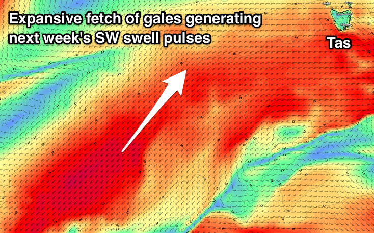
At the base of the second front, a better fetch of SW gales projecting towards us should produce a stronger S/SW groundswell pulse for Tuesday morning to 3-4ft off Middleton and winds again look to be favourable and out of the W/NW around Victor before tending W/SW.
One final frontal system is then forecast to project a fetch of SW gales right up and into us, through the middle of next week. The models diverge on this slightly but if it occurs the South Coast will see a large stormy swell kicking in, cleaner on the Mid and small and fun. More on this Friday.