Average outlook with only one decent day

South Australian Forecast by Craig Brokensha (issued Friday 1st February)
Best Days: Saturday morning South Coast swell magnets
Recap
Onshore winds though OK waves for desperate surfers who missed out earlier in the week on both coasts yesterday, back to 3ft off Middleton and 1-1.5ft+ on the Mid. The Mid started to clean up into the afternoon and further this morning with a strong offshore, but the swell has all but gone. The South Coast was a junky and messy 2-3ft.
Today’s Forecaster Notes are brought to you by Rip Curl
This weekend and next week (Feb 2 - 8)
Over the weekend we'll see the swell continue to ease back in size but the South Coast should be much cleaner and fun on the magnets. A light N-NE offshore wind is expected across most breaks, though the swell will be small and easing from 2ft off Middleton, slightly bigger at more exposed breaks.
Sea breezes will kick in through the afternoon, while Sunday should see offshore winds again out of the N/NE tending N/NW ahead of a gusty S/SW change mid-afternoon as a surface trough moves in from the west.
Size wise there'll be nothing of note at Middleton with tiny peelers ideal for beginners, with maybe the odd 2ft'er at Waits and Parsons.
The trough moving in Sunday will unfortunately leave gusty S/SE winds into Monday across the South Coast with a mix of poor S/SE windswell and inconsistent increase in long-range SW groundswell.
 The groundswell has been generated the last couple of days by a strong and slow moving low south-west of WA and will only provide inconsistent 3ft sets off Middleton into the afternoon, 1ft on the Mid (possibly a touch bigger with the incoming tide).
Also in the mix should be a W/SW windswell from the trough on the weekend, but this looks very minimal now and only 0.5ft to maybe 1ft.
Tuesday will remain poor down South with onshore SE winds as the inconsistent SW groundswell eases.
Into Wednesday a new mid-period S/SW swell is due on the South Coast, generated by a weaker front moving through our swell window Sunday and Monday. This front was expected to be stronger, generating a good SW groundswell for Tuesday, but with it being weaker, the timing has been delayed.
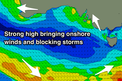
Only a 2ft+ wave is expected off Middleton Wednesday and winds unfortunately look to linger out of the S'th, creating average conditions. It doesn't look like we'll see any letup in the onshore breeze at all. This will be a result of back to back high pressure systems filling out the Bight, blocking swell at the same time.
This will hopefully be broken down by a cold front late next week, but more on this Monday. Have a great weekend!